Spalding, Lincolnshire. Perhaps not one of the most prosperous towns in England these days, but it does hold a personal hangover fascination from me via my Lockdown-era MonasteryQuest™ project, in that it had an important Benedictine Priory that has almost entirely disappeared, and its status within the architecture of English monastic churches completely forgotten. I have always intended to come back to it, so ahead of scheduled lunch break on a tour this summer, having prepared via research and street view,1 I had a whizz-round exploration of the priory site. Even though it’s hardly revelatory, I thought it would be worth dumping all I found here on my website.
Contents
- Mapping medieval Spalding
- The site of the priory church and its conventual ranges
- “Abbey Buildings”
- 1 Sheep Market (“The Prior’s Oven”)
- The Hole-in-the-Wall Tower
- The Great Gatehouse
- The parish church of St Mary and St Nicholas
- Ayscoughfee Hall
Spalding Priory, with its gross annual income of £878, 18s., 3d., ranked no. 38 in the Valor Ecclesiasticus of 1535, putting it in the lower part of top rank of English monasteries, alongside houses such as Selby Abbey in Yorkshire (£829 gross) and Smithfield Priory in London (now better-known as St Bartholomew the Great, £773 gross). Significantly, it is the second-wealthiest house where we do not have any idea of the plan or even the precise location of the church (the wealthiest entirely-vanished conventual church is the Fenland abbey of Ramsey in Huntingdonshire, although there are more survivals of the wider monastic complex there).
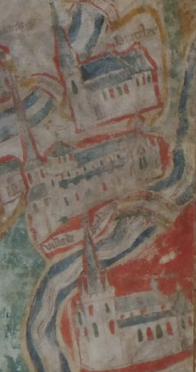
Detail of The Pinchbeck Fen map, National Archives MPCC 1/7
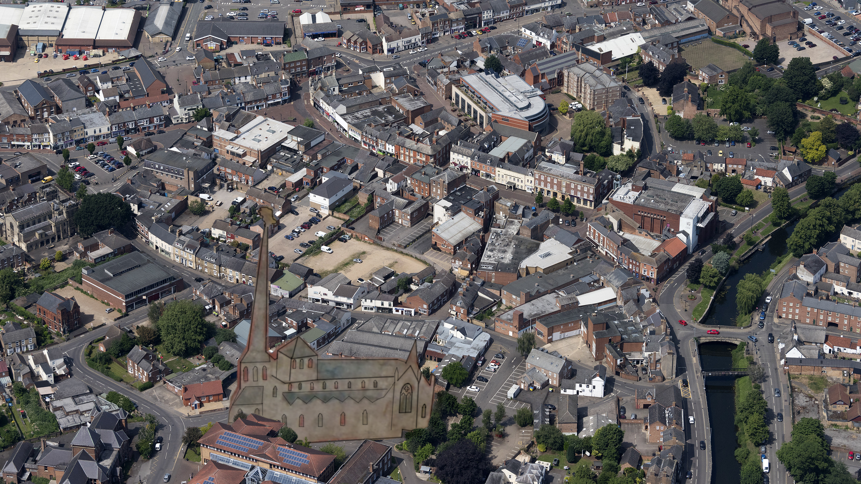
A likeness of the lost great church of Spalding Priory was captured on the spectacular illuminated vellum generally known as the Pinchbeck Fen Map (right) that was preserved in the archives of the Duchy of Lancaster, and now lives in the National Archives at Kew.2 This highly unusual object, likely made around 1430 has been demonstrated to show a remarkable degree of similitude in the parish churches in depicts, and was likely made at Spalding Priory in order to illustrate and codify parochial grazing rights in the sought-after fertile soil of the fen.3 Therefore the depiction of the church should be taken as a carefully representation of its actual appearance, rather than a generic cipher of a church as is often the case on most maps.
The Pinchbeck Fen map was only recognised in modern scholarship as being of pre-Reformation date in 1997, although it was clearly known beforehand, as the 1732 Grundy Map of Spalding that will be referred to a lot in this investigation utilises its portrayal of the priory church.4 The depiction of Spalding Priory seems to have an axial western tower embraced by the nave aisles, fronted by a aisle-height projection, perhaps a galilee porch akin to fellow Fenland monastery Ely Cathedral, flanked by a second tower with what looks like a slender lead-covered splay-foot timber spire. All this suggests a complicated western block along the lines of another Fenland house Peterborough Abbey. A gabled transept seems to almost be at the end of the church, suggesting that it did not have an elongated eastern arm beyond the main crossing, perhaps, instead – most excitingly – it looks almost as if it could have a polygonal apse with a radiating chapel. The Peterborough Chronicle (British Library, Cotton MS Claudius A V, ff 2–45) tells us the church was rebuilt under Prior Simon, who died in 1252.5
Spalding Priory has an origin that is generally misunderstood, so I will sort it out here as simply I can. Much of what is in the single existing volume of the Lincolnshire Victoria County History that is the first point-of-call for researchers is now widely recognised to be based off a faulty late medieval source.6 According to the so-called Historia Ingulphi, purporting to be written by a late eleventh-century abbot of Crowland Abbey, Spalding was founded as a cell of Crowland, for a prior and five monks by Thorold, Sheriff of Lincoln in 1051.7 In a simple Normans versus Anglo-Saxons yarn, the pseudo-Ingulph tells us that the post-Conquest lord of the manor Ivo Tailbois, “at the instigation of the Devil”, was extremely belligerent to the Priory and their livestock, forcing them out of town, and when the one monk sent from Crowland on alternate days to say the Divine Office drowned in a great tempest, Earl Ivo was “overjoyed that the Lord even seemed […] to be fighting with him against [Crowland]”.8 It is this almost pantomime villainy that is the background to a claimed transfer of the monastery at Spalding from Crowland to the Abbey of St Nicholas in Angers. However, this story appears to be an entirely a later medieval interpolated fiction to help Crowland make a claim as the aggrieved elder party in its bitter rivalry with the relative upstart Angevin priory.9 In fact, it appears most likely that Spalding was never a cell of Crowland, and that Thorold was born in Normandy and he himself established a link with the monastery in Angers via land grants that led to the establishment of a priory under Ivo in the 1080s, who succeeded Thorold by marrying the heiress Lucy, who may have been Thorold’s daughter.10
Whatever her origins, Lucy’s successive marriages to Roger FitzGerold (producing William de Roumare, made first Earl Lincoln by King Stephen c.1140) and Ranulf le Meschin, 3rd Earl Chester, provided the priory with powerful secular support in increasing its wealth and ultimately asserting its conventual independence from the abbey in Angers.11 This keenness to separate from the continent ensured the priory was relatively unaffected by the increasing aggression shown towards alien priories and their assets during the wars with France, which cumulated in their wholesale suppression under Henry V in 1414. The Priory was in a powerful enough position to make engagements with the Crown: we are told Prior Simon (r. 1229-53) invited King Henry III to his banquet in London with numerous earls and barons, which upset the Bishop of Lincoln (likely Robert Grosseteste) presumably on its lack of Benedictine spirit.12 Edward II seems to have stayed at the Priory 24 Oct 1315, which would mean it had extensive lodgings to take the King and his retinue.13
Mapping medieval Spalding
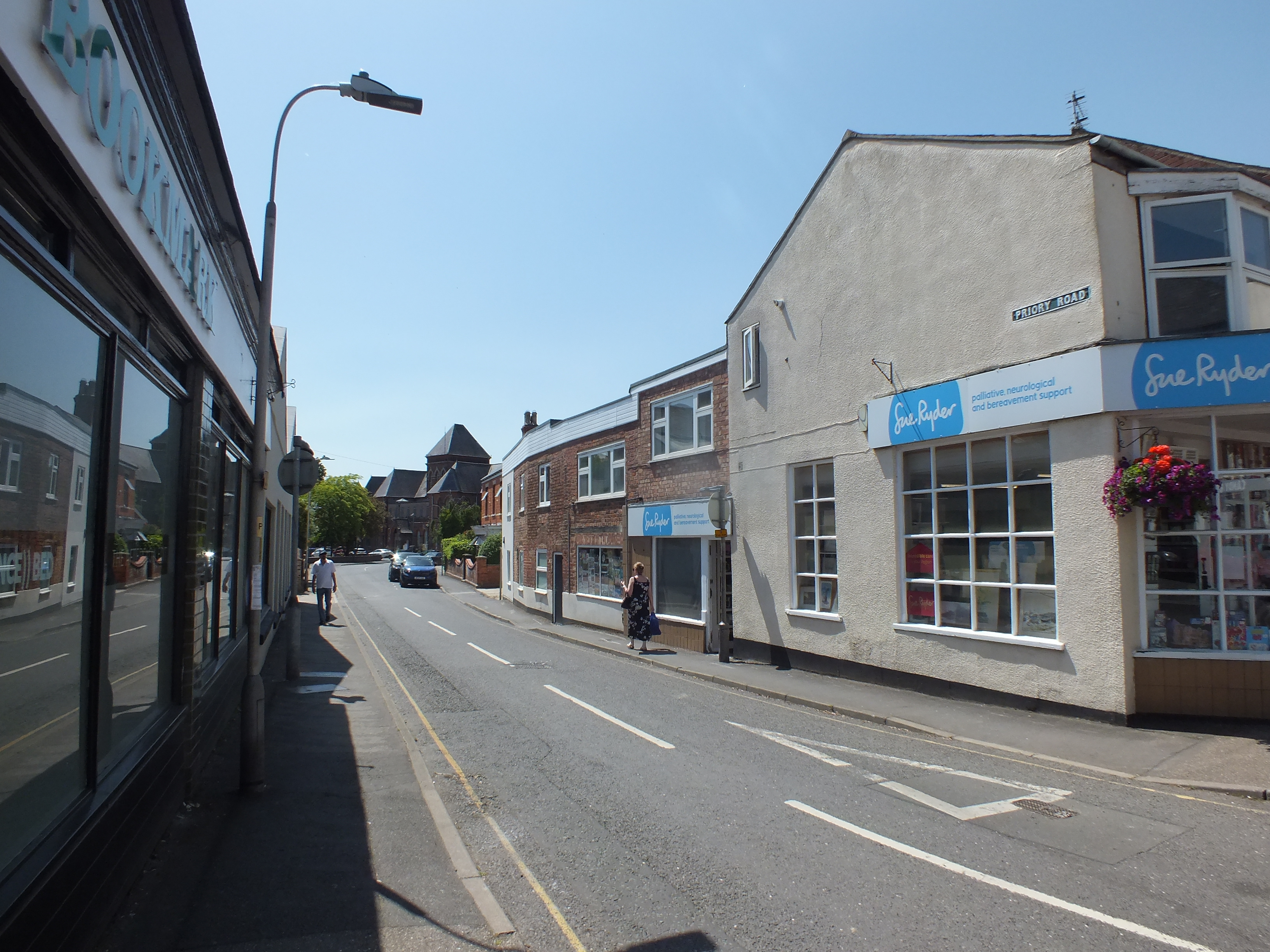
Spalding Town centre is an odd place to explore, as the two medieval market places that comprise the main retail areas form a dog-leg around the former site of the priory precinct, which is often a warren of narrow alleyways and car parks, with a somewhat surprising traffic thoroughfare through its centre in the form of The Crescent.
For William Dugdale’s (1605-86) Monasticon Anglicanum, the print that Wenceslaus Hollar (1607-77) produced for the priory of Spalding is very unusual compared to his typical output regarding recording old monasteries. Presumably because there was so little left of the buildings of the priory by the mid-seventeenth century (although, as we will see, there were some bits), rather than depicting individual elements, he made a rather bare-bones diagrammatic plan of the outlines of its precincts, ignoring the thriving town in the triangle between the two branches of the River Welland to concentrate on the boundaries of the vanished monastery’s precincts.
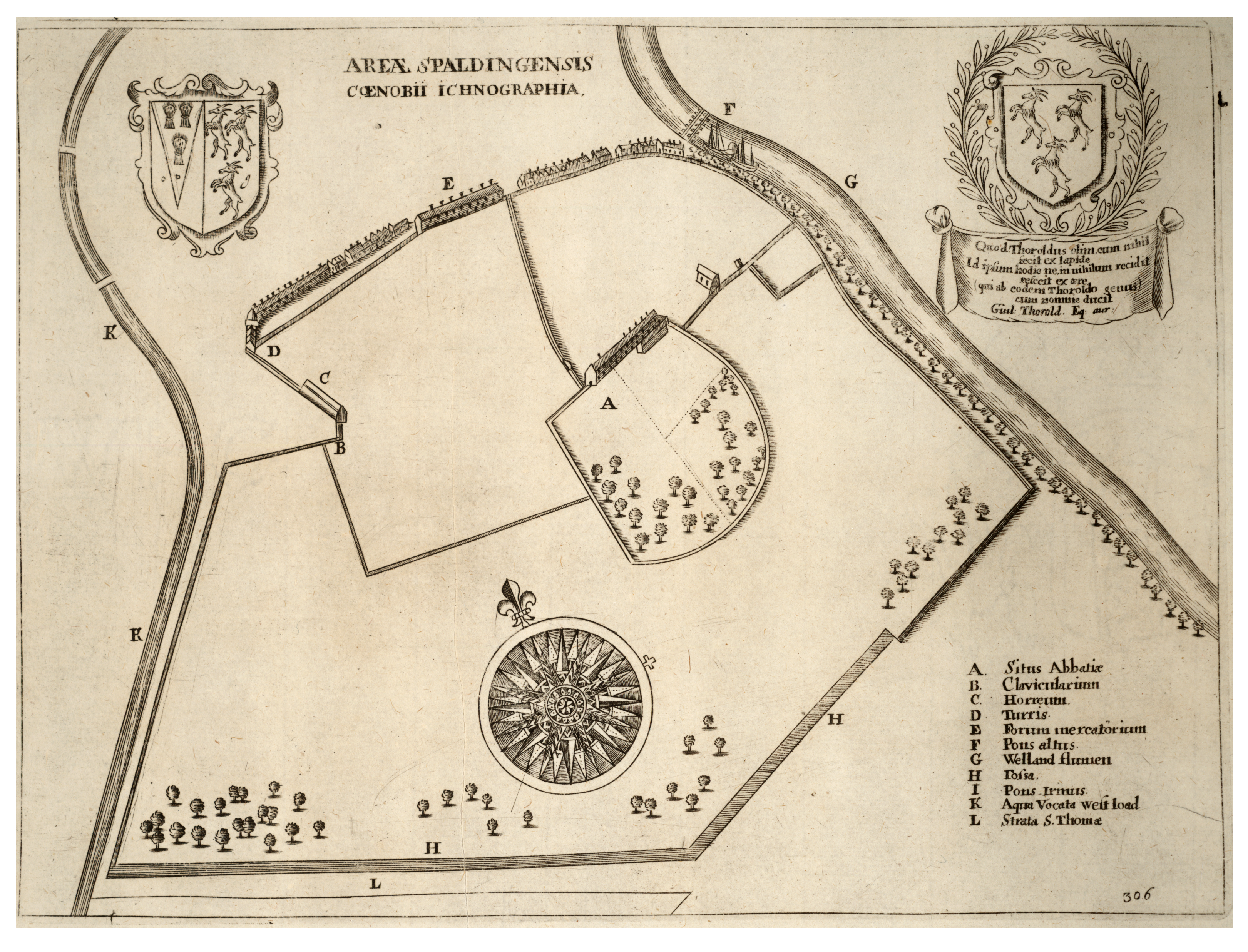
Hollar’s key is as follows:
A. Situs Abbatæ (Site of the Abbey)
B. Clavicularium (Gatehouse)
C. Horreum (Barn)
D. Turris (Tower) [The Prior’s Oven]
E. Forum Mercatorium (Market place)
F. Pons Altus (High bridge)
G. Welland Flumen (River Welland)
H. Fossa (Ditch)
I. Pons Irinius (Low bridge)14
K. Aqua vocata Westload (Water called the Westlode)
L. Strata St Thomæ (St Thomas’ Causeway)
The heraldry of three goats salient is that of Thorold, the claimed founder of the monastery. Sir William Thorold (d.1678) was made a baronet by King Charles I in 1642 and he clearly contributed towards the production of the plate (either by means monetary or informational).15
Although no scale is given, it is fairly straightforward to superpose Hollar’s plan over modern maps to get an idea of the size of Spalding Priory’s curtilage, the memory of which Baronet Thorold was keen to preserve. It consisted of an inner precinct under the market places, a conventual precinct at the centre, a segment to the north-east that may have been the prior’s court,16 and then the agricultural lands of the outer precinct below.17
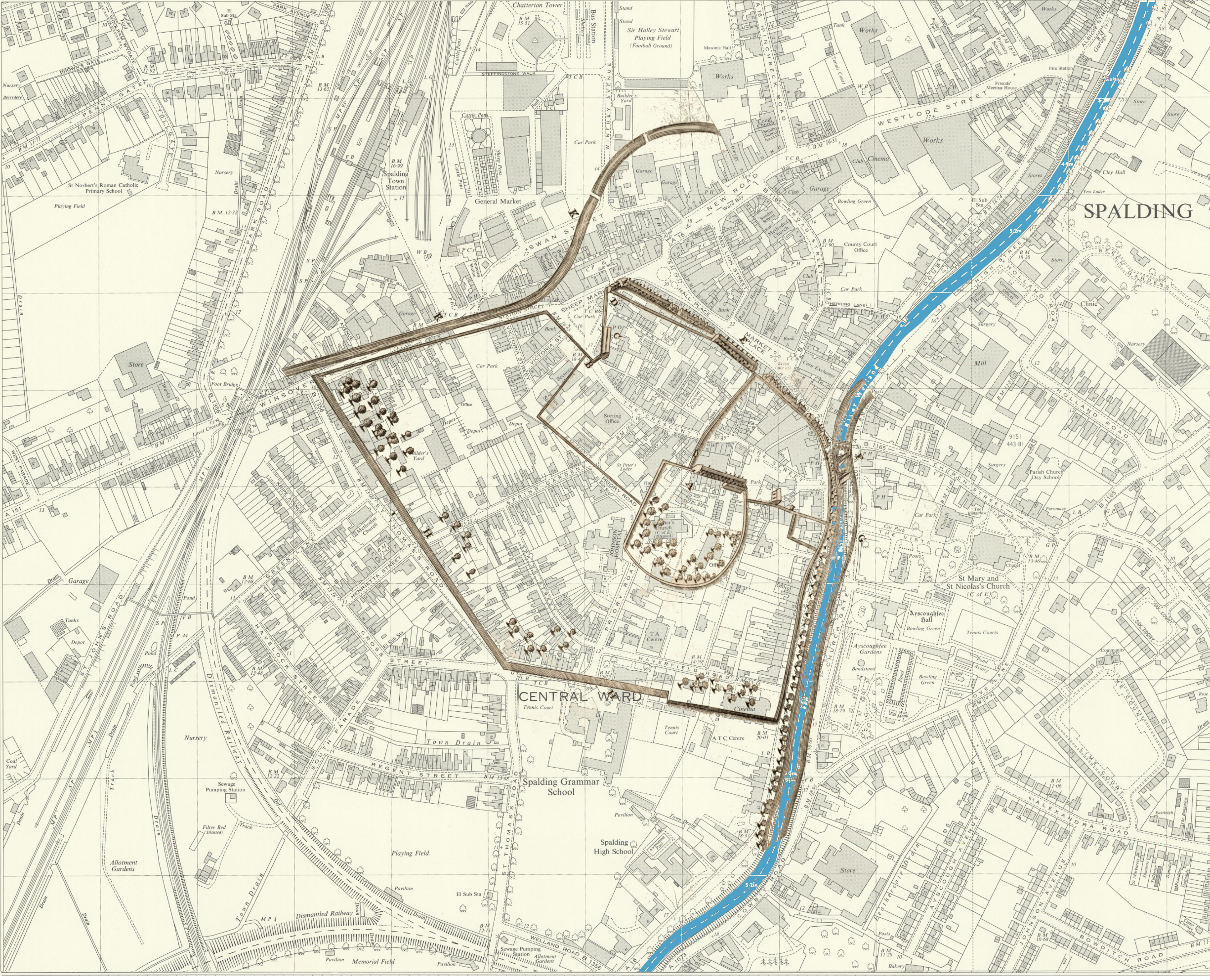
Current path of the River Welland in blue.
I chose to use the 1960s OS map in this overlay as it shows the transition of Victorian to modern Spalding. As well as the lost railway lines to March and Sutton Bridge branching off the current mainline to Peterborough, it shows an interesting lost feature of the town: the Victorian St Peter’s church, which formerly stood bang in the centre of the priory’s conventual precinct, which we shall look at shortly.
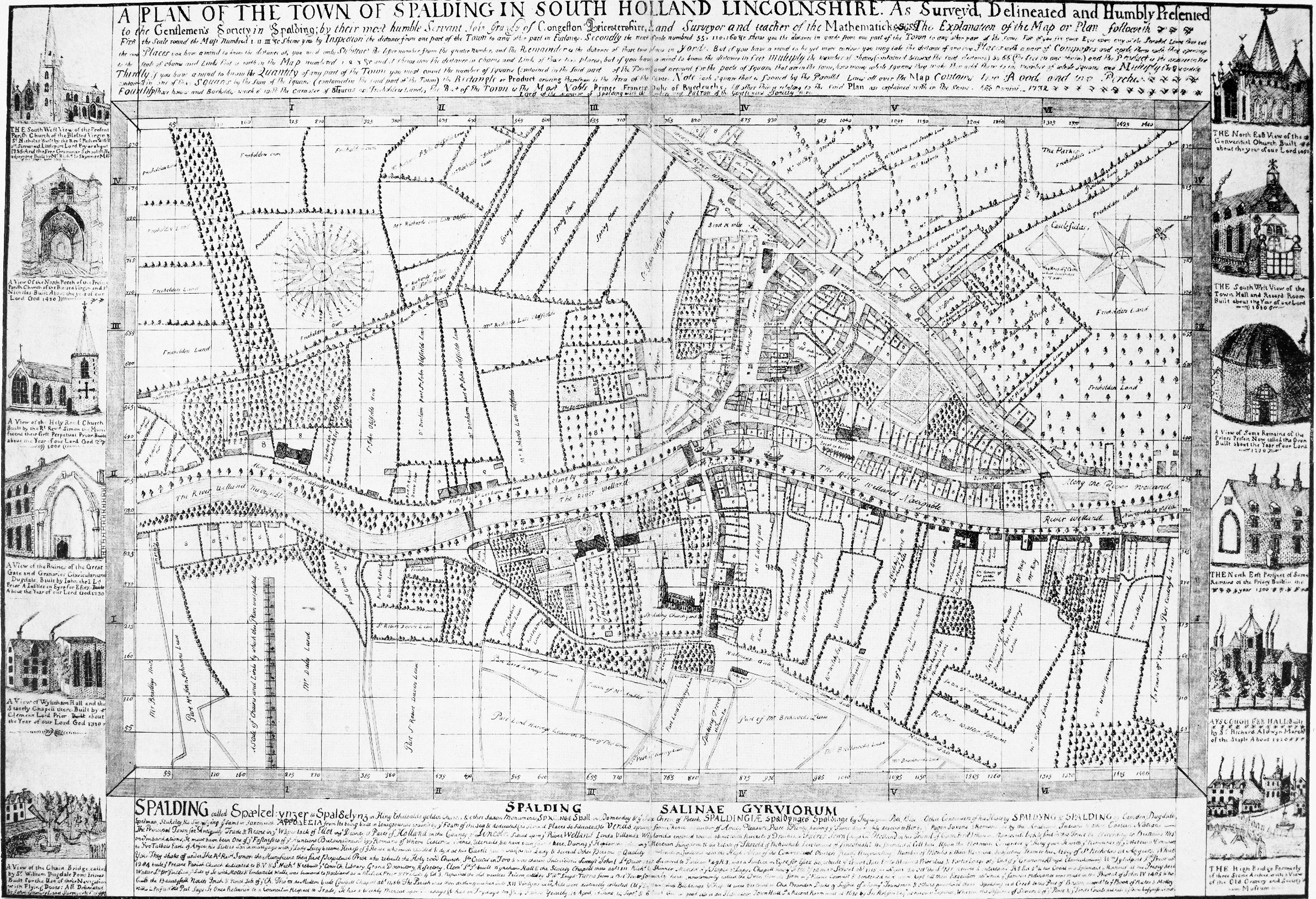
Before the nineteenth century, the former site of the Priory continued as orchards and fields, as can be seen in the exceptionally informative source that is the map of the town made for Spalding Gentleman’s Society by the surveyor and hydrological engineer John Grundy in 1732. You can see at this point the town was still in the triangle between the two branches of the River Welland (the western one known as the Westlode now fully culverted), with the site of the priory still almost entirely agricultural.
The site of the priory church and its conventual ranges
In the absence of archaeology for the priory church of Spalding, it is interesting to compare the topography of the recorded priory environs to see what size of church and claustral range it would permit. The size of Hollar’s Situs Abbatæ, beyond any reasonable doubt the site of the conventual church and the main cloister, is intriguing because it is not very big (110 m W-E). It is, however, just is enough to accommodate the length of church of the Abbey of Selby (95 m), which as noted above had very similar wealth. The image below shows the location of surviving fragments we look at subsequently, but also overlays Selby Abbey to scale in RED. However, it should be remembered in the Pinchbeck Fen map, probably made at the Priory c.1430, the church is shown not to have much beyond its transepts, suggesting it did not have a similarly proportioned eastern extension to Selby.
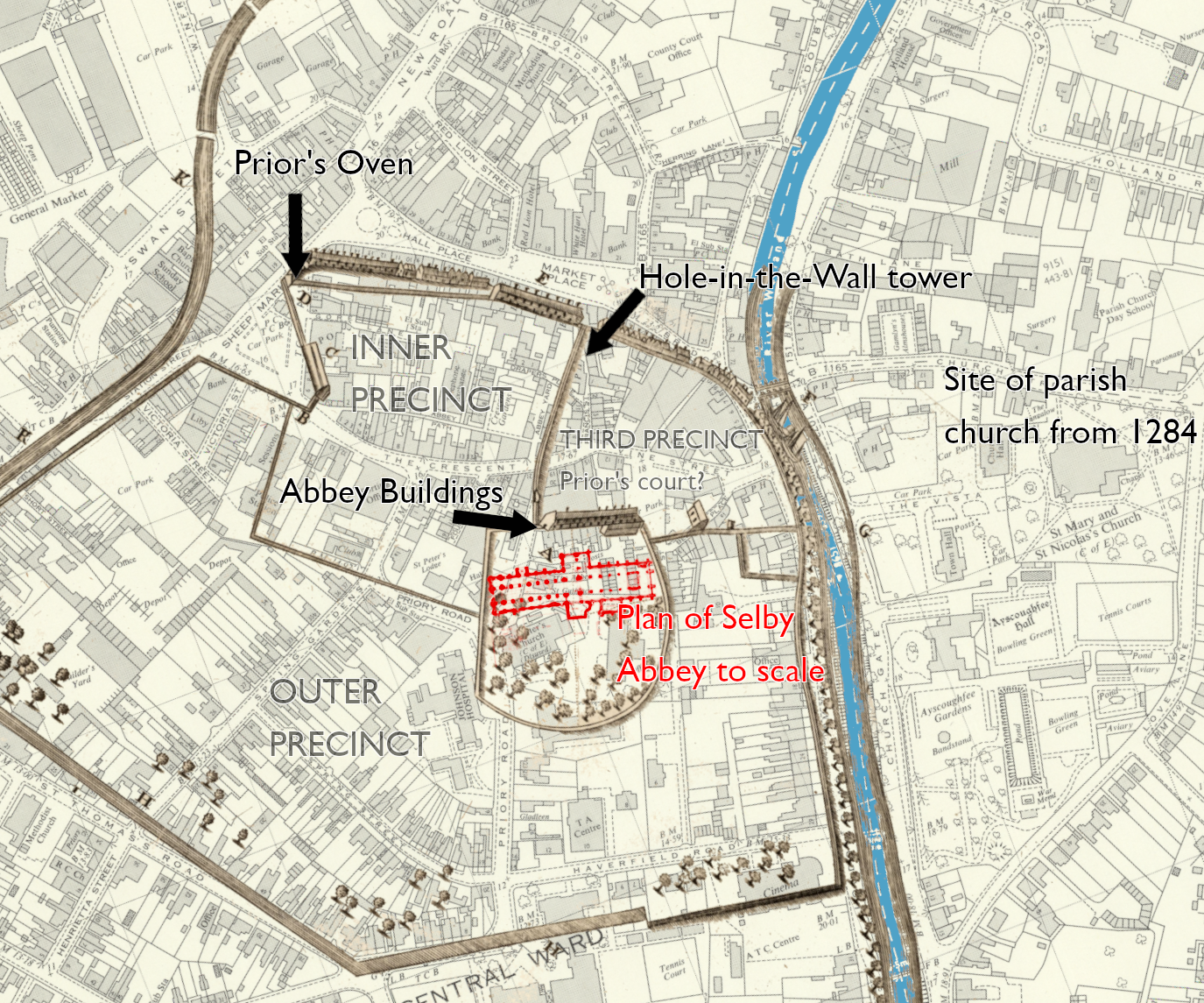
The accuracy of the Hollar plan is given credence by the precisely plotted 1732 Grundy Map, which shows how the town was still above of the former priory precinct, with a fashionable suburb developing on the east bank of the River Welland, while the former monastic grounds remained as enclosed pasture and orchards. Notably, the boundary under Abbey Buildings that corresponds with the conventual precinct is still discernible by its use as orchards rather than fields.
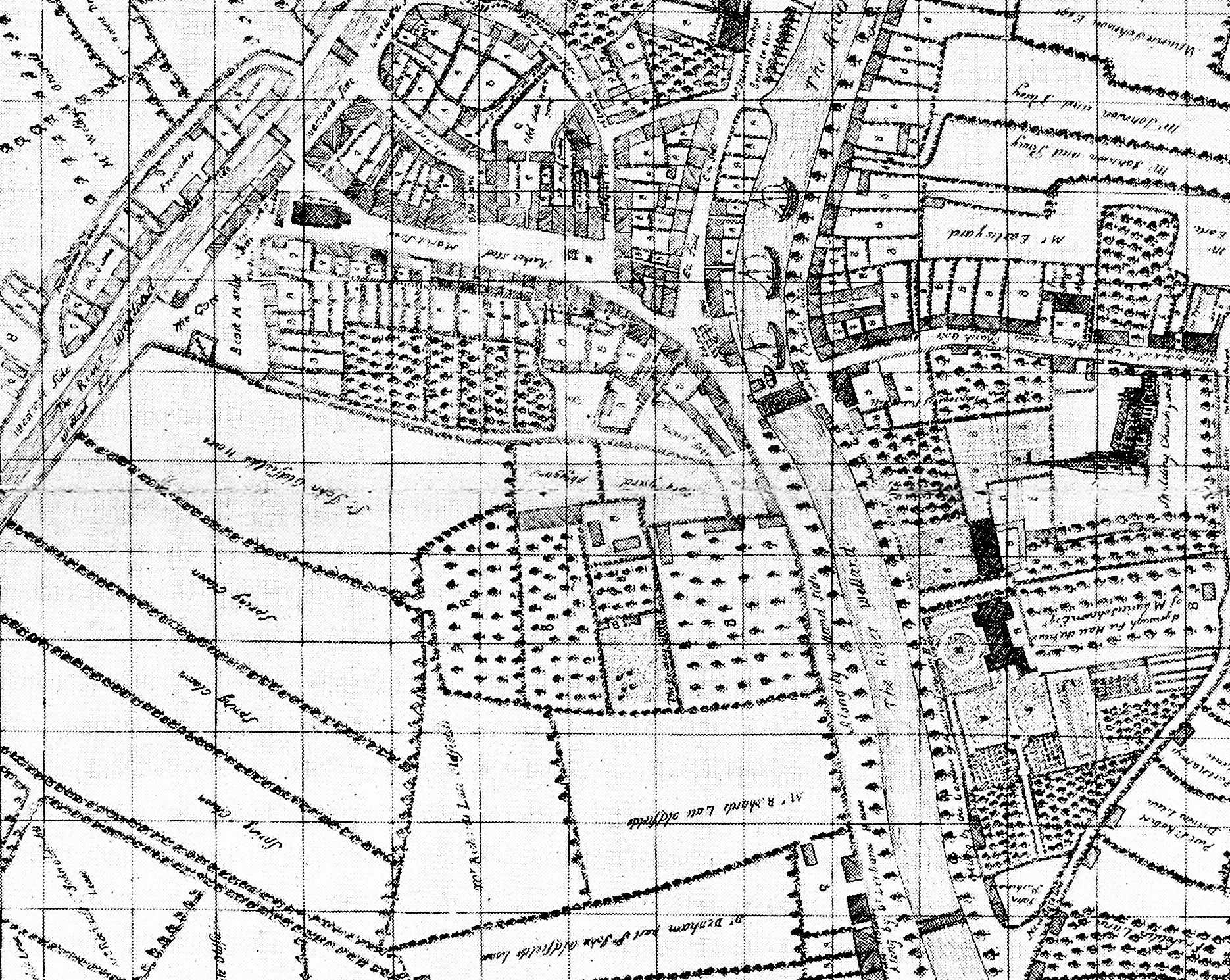
Gradually fields were acquired for building domestic properties in the nineteenth century in the monastic precincts, leading to the whole site being eventually almost entirely built over. A church dedicated to St Peter was built at its heart for the new population to save them crossing the Welland to the medieval parish church.
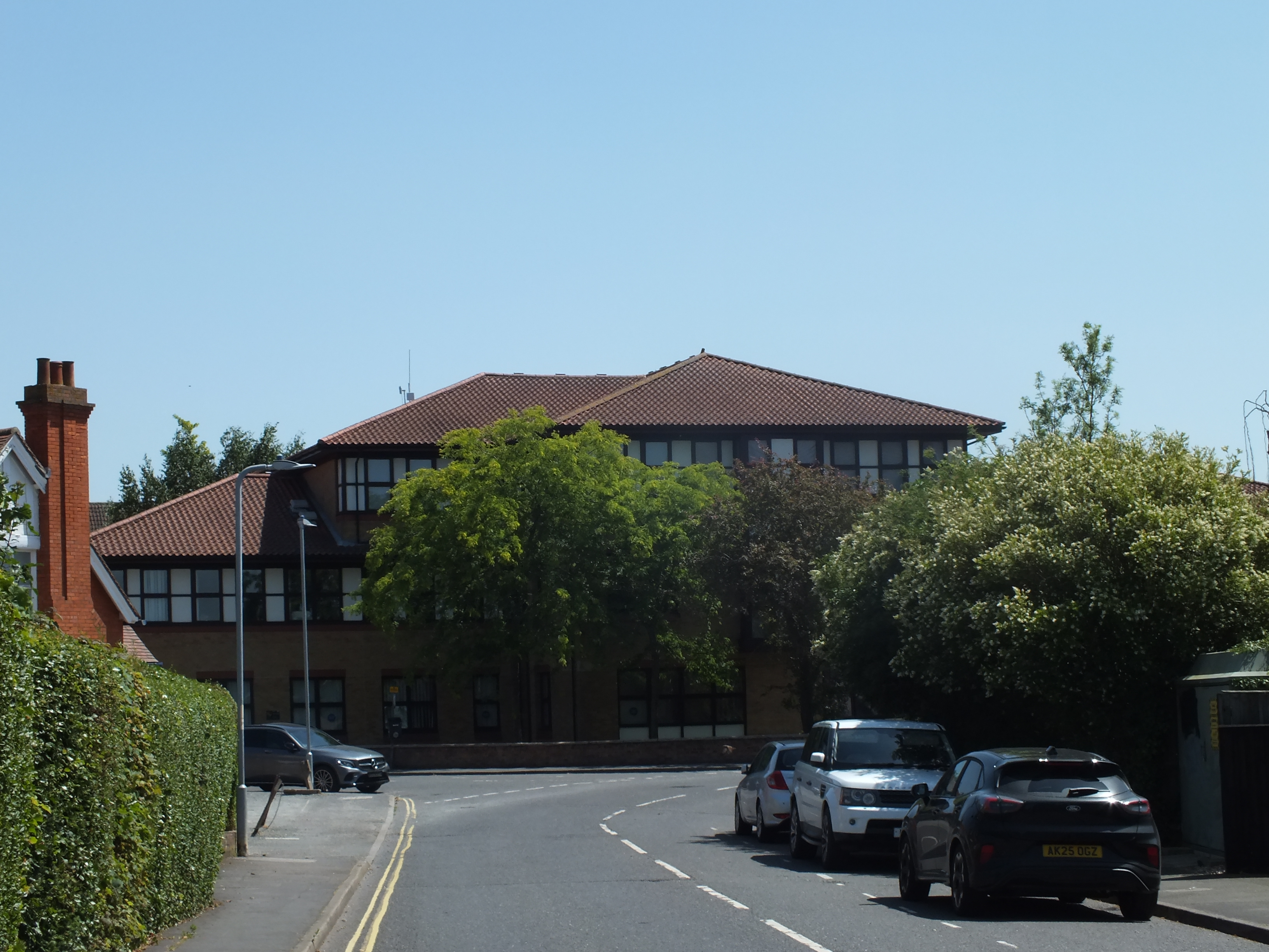
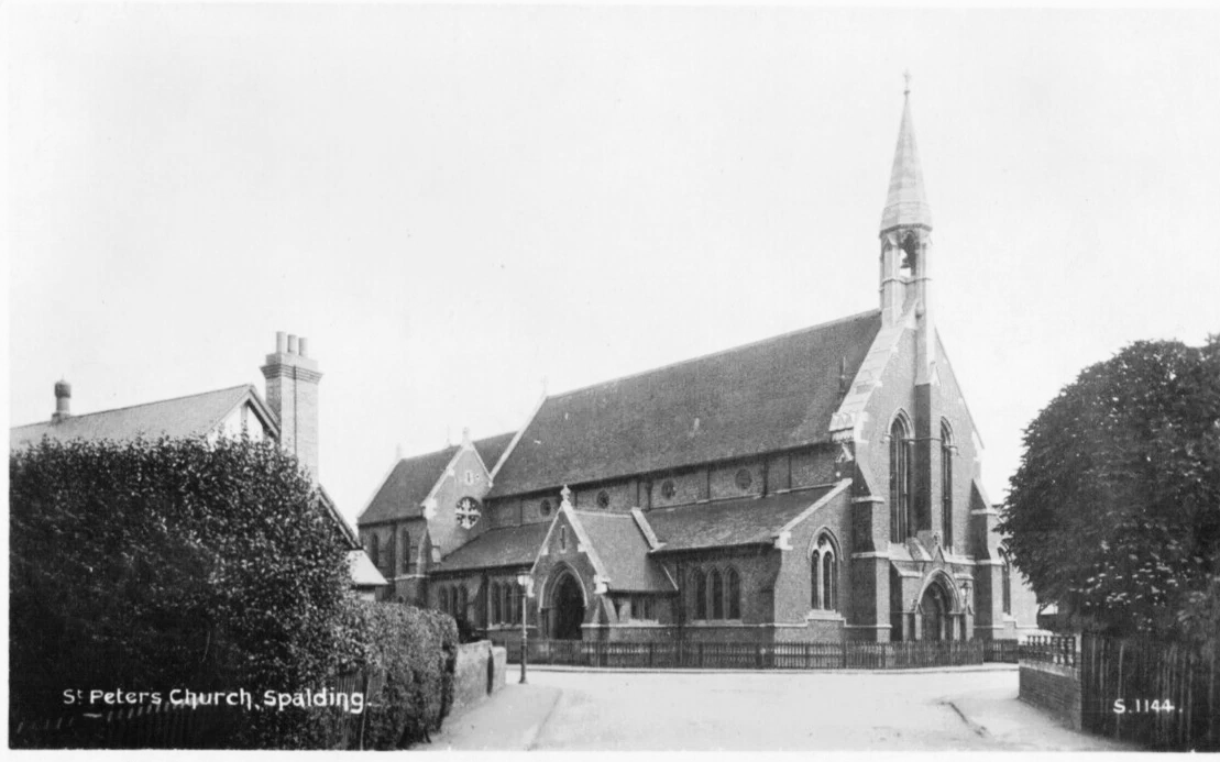
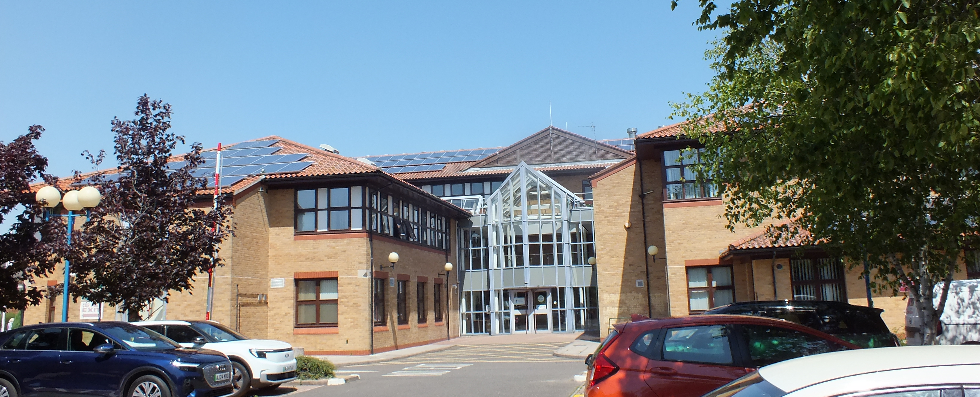
St Peter was designed by the office of the prolific architect George Gilbert Scott and built 1875-6.19 Struggling to draw a congregation even in the 1930s,20 it was demolished in 1968, and built over with a faintly-Mock-Tudor postmodern extension of the offices of the South Holland District Council in 1991. One does wonder how many of its employees realise the significance of the site, especially as it does deal with planning applications and knocking stuff down. To be honest, it’s not a terrible building by any measure, but it is very reminiscent of the cosy safeness of the mock-domestic brick cladding of contemporary supermarket sheds, and cannot instil a great deal of civic pride.21
Although nothing to do with the medieval monastery, it is worth dedicating some space here to the grand High-Victorian gothic pile of the Johnson Memorial Hospital that now sits opposite the Council Offices in a sadly empty state.
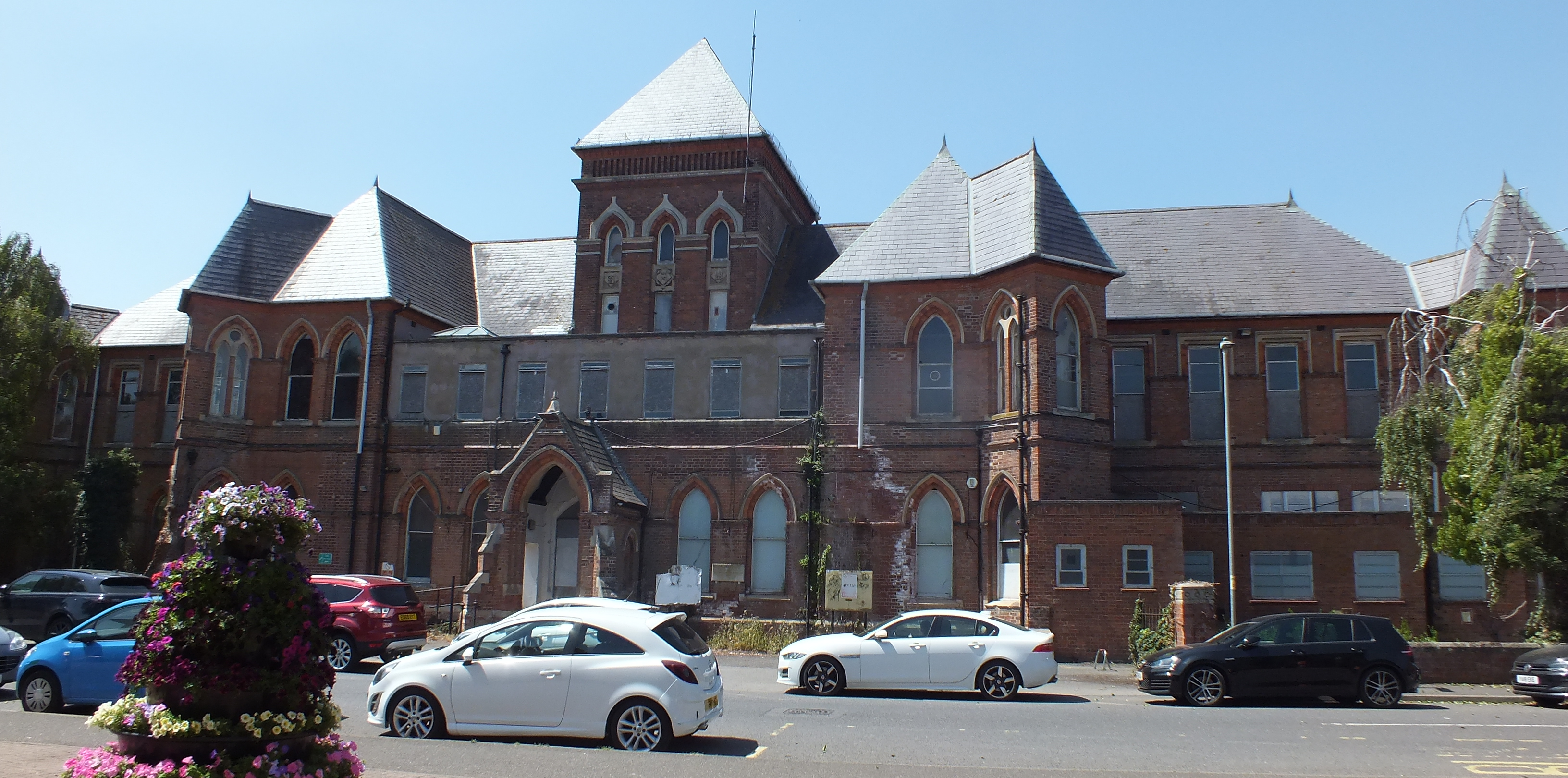
Built 1879 by London architectural partnership Weatherly and Jones,22 it continued as a NHS point of service until 2009 when a new building, named after it as the Johnson Community Hospital, opened on an enterprise zone to the north of the town.23 The Victorian building was sold in October 2010 for the paltry sum of £180,000 for potential development into flats, which never happened.24 The current owners, under a shell company based in the British Virgin Islands, pay exceedingly small business rates due to its former function as a hospital25 and clearly have no intention of doing anything with it for the foreseeable future, helped by Historic England who have refused to grant the building listed status.26 All together a desperately sad situation for a public building that was gifted to the town by the legacy of two sisters to be left to decay as a private long-term asset due to reckless flogging off of municipal architecture.27
“Abbey Buildings”
An understudied standing building from the priory is just to the north of the South Holland District offices. The rather tersely (and inaccurately) named Abbey Buildings is a range of roughly-coursed red brick with Barnack limestone dressings, and often described as constructed from remains of the priory after its dissolution, but it is more likely it is a building from the time of the priory, probably early fifteenth century, modified by the insertion of oblong windows in the seventeenth century.
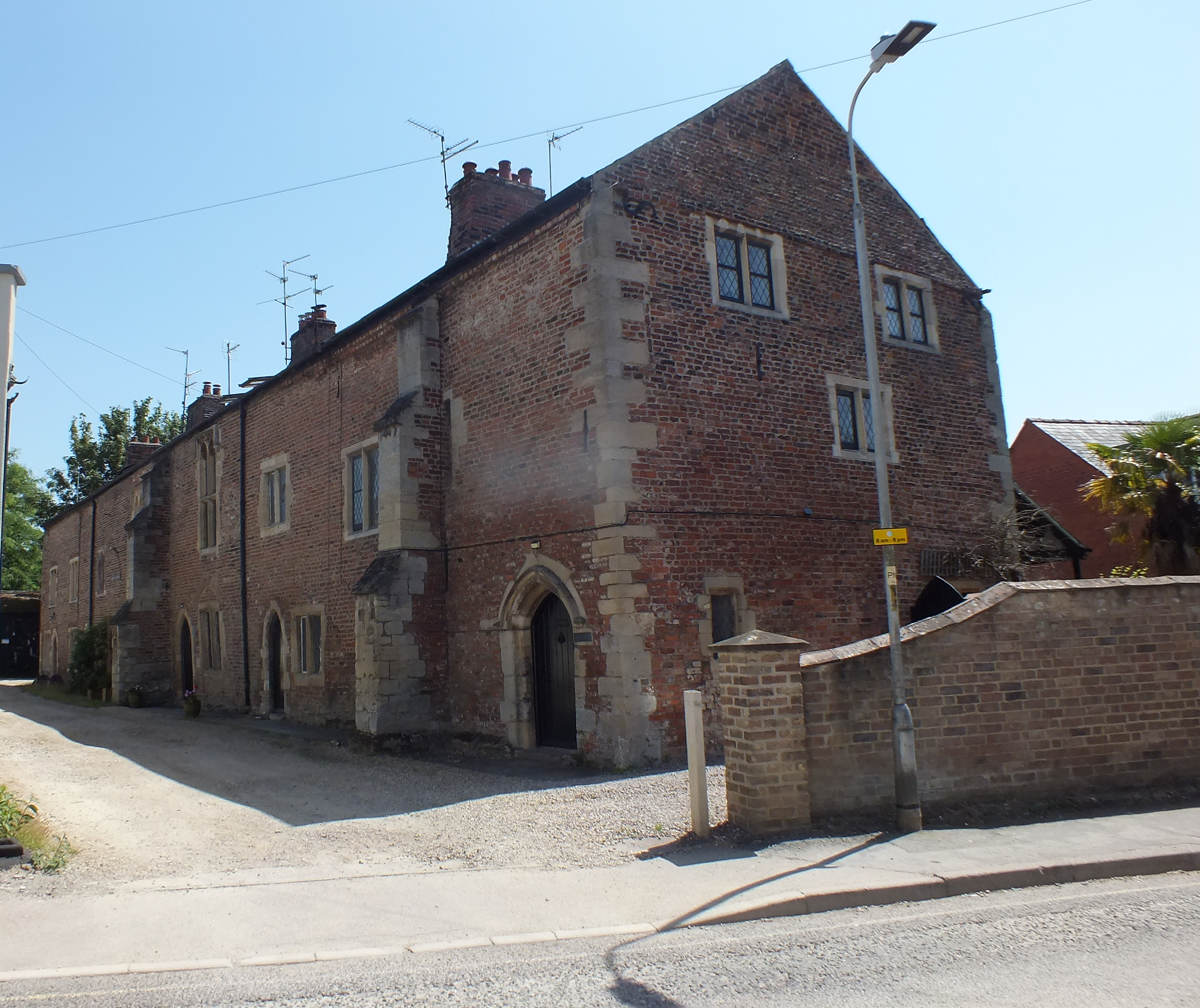
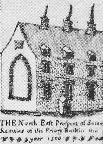
Hollar would appear to depict it as forming part of the northern boundary of the conventual precinct, and it is one of the 12 buildings shown around the 1732 Grundy Map, where it is described as seen from the north east. The notable feature on the Grundy view (below) is what appears to be a large blocked window in the terminal wall. This is no longer apparent, although the brickwork of the east wall is noticeably uneven and clearly patched up in places.28
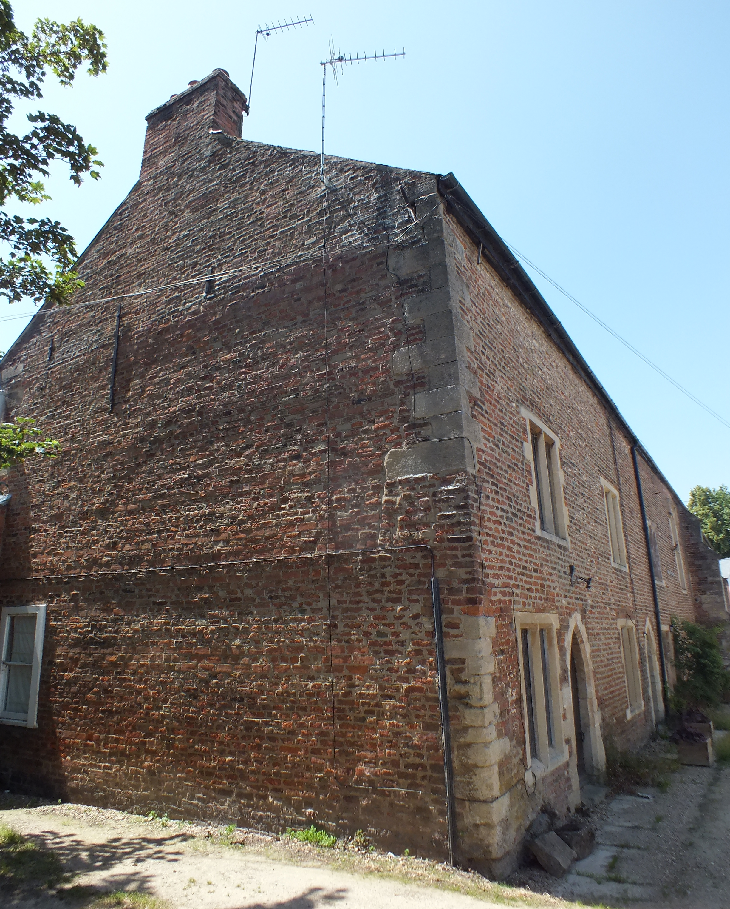
The original fenestration seems to be the square-headed two-light windows with a transom, with cusped trefoil heads (ogival on the south side). The other major feature is the brick buttresses faced with three series of set-offs in limestone: two on the north side, and six on the south (which define the seven residential properties it is now divided into). What the range was originally built as is difficult to deduce, because although clearly was not part of the main Benedictine claustral ranges such as the dormitory or the refectory, its closeness to the conventual heart of the priory complex makes it impossible that it was part of the Benedictines’ required facilities for laypeople such as a guest house or almonry.29 Was it originally an infirmary range, perhaps with an unvaulted undercroft?30 Needs more than me just having a look round it on a lunchbreak, really. The seven properties, of varying solutions for putting a dwelling inside a 34 m² footprint, have recently sold from £155k to £275k.31
1 Sheep Market (“The Prior’s Oven”)
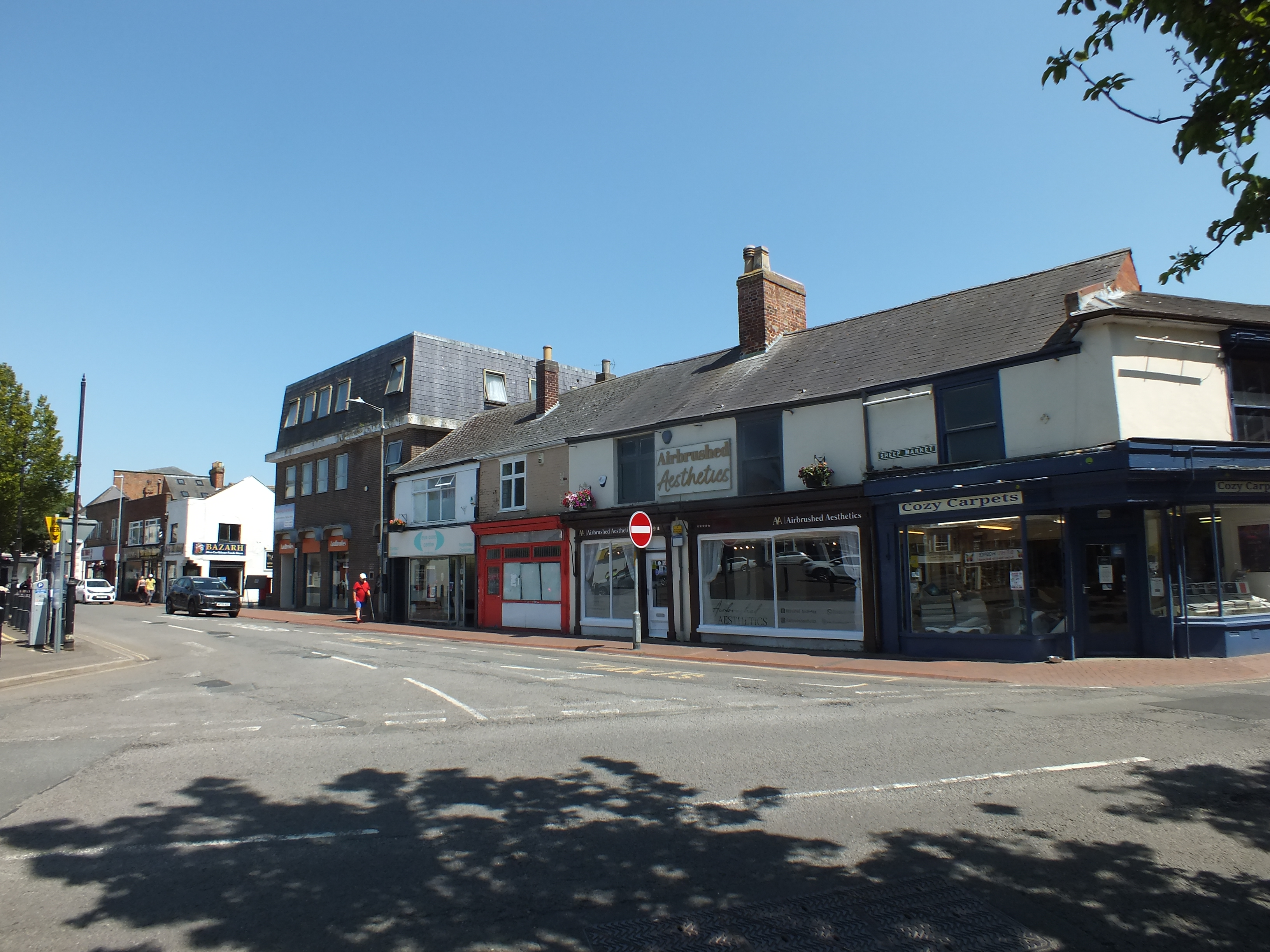
The most famous survival of Spalding’s priory buildings is 1, Sheep Market, popularly known as “The Prior’s Oven”, most likely entirely inspired by the domed roof it exhibited until it was raised by a storey in the early nineteenth century rather than any genuine folk memory of its original function. Labelled as D. and called “turris” on Hollar’s plan, what is was originally meant to be as a building around the main gatehouse from the town into the priory’s inner precinct, although it was later used as a prison and blacksmith’s house.32
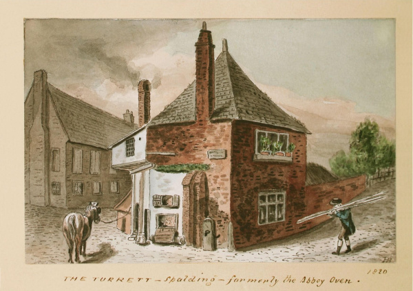
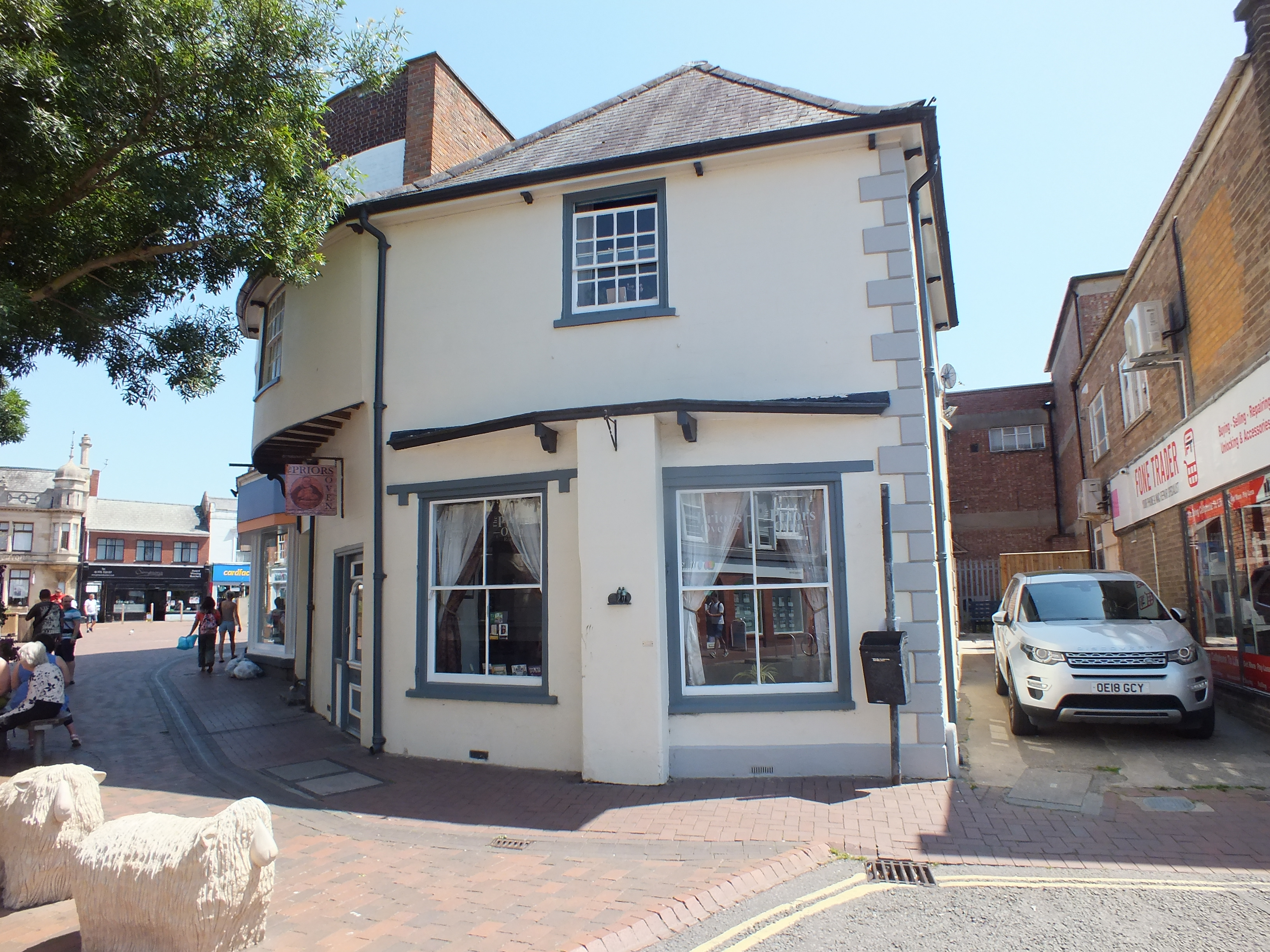
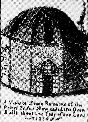
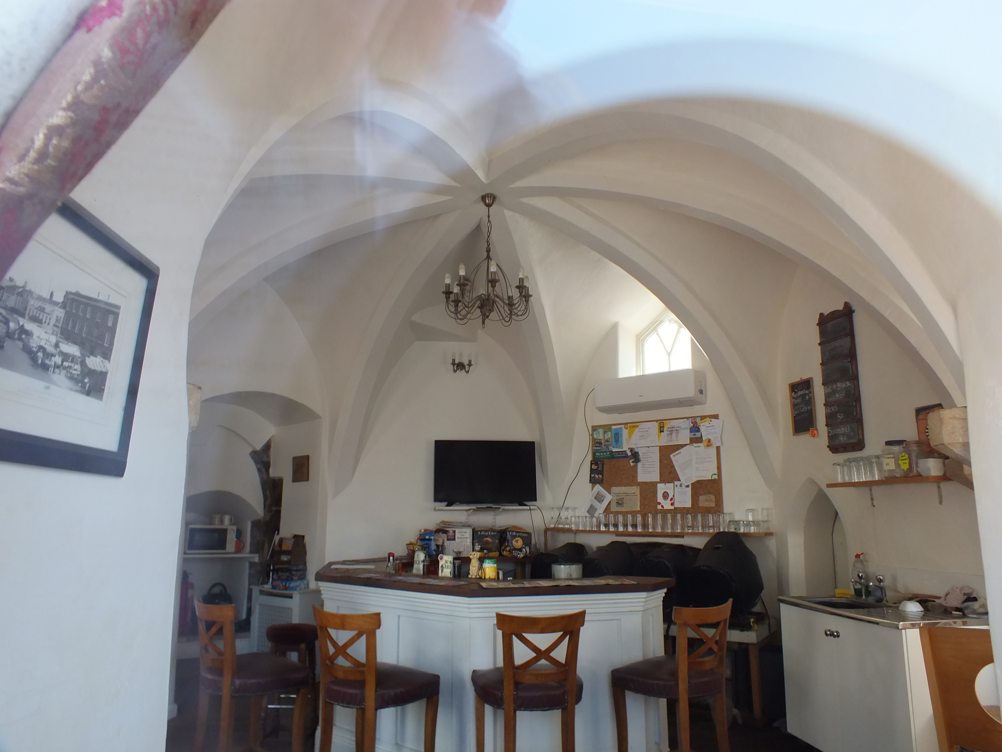
Inside, there is a striking ceiling (originally part of the roof?) of 8 simply chamfered ribs, very much of the appearance of a stone vault, especially the arching of the cells in between: but by all account the ribs are timber. Is it even medieval? This is a case where some carbon-14 samples to get even a ballpark felling date would be very interesting. However, wood is clearly not an ideal covering for either an oven or a prison! And indeed it is a challenging space to run as business premises on account of its small size, however since 2013 it has been owned and run as a cozy micro-pub,33 which I could only snap through its nineteenth-century fenestration.
The Hole-in-the-Wall Tower
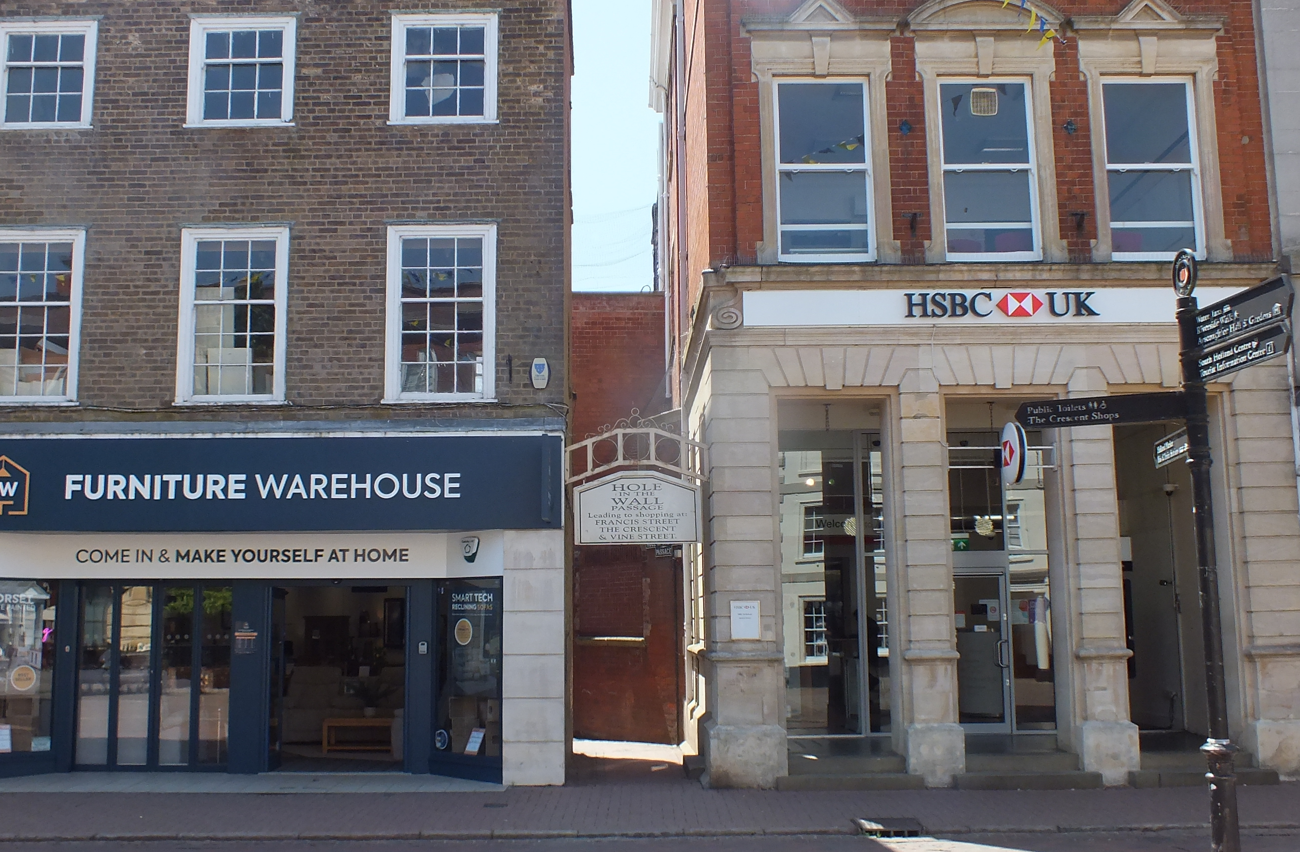
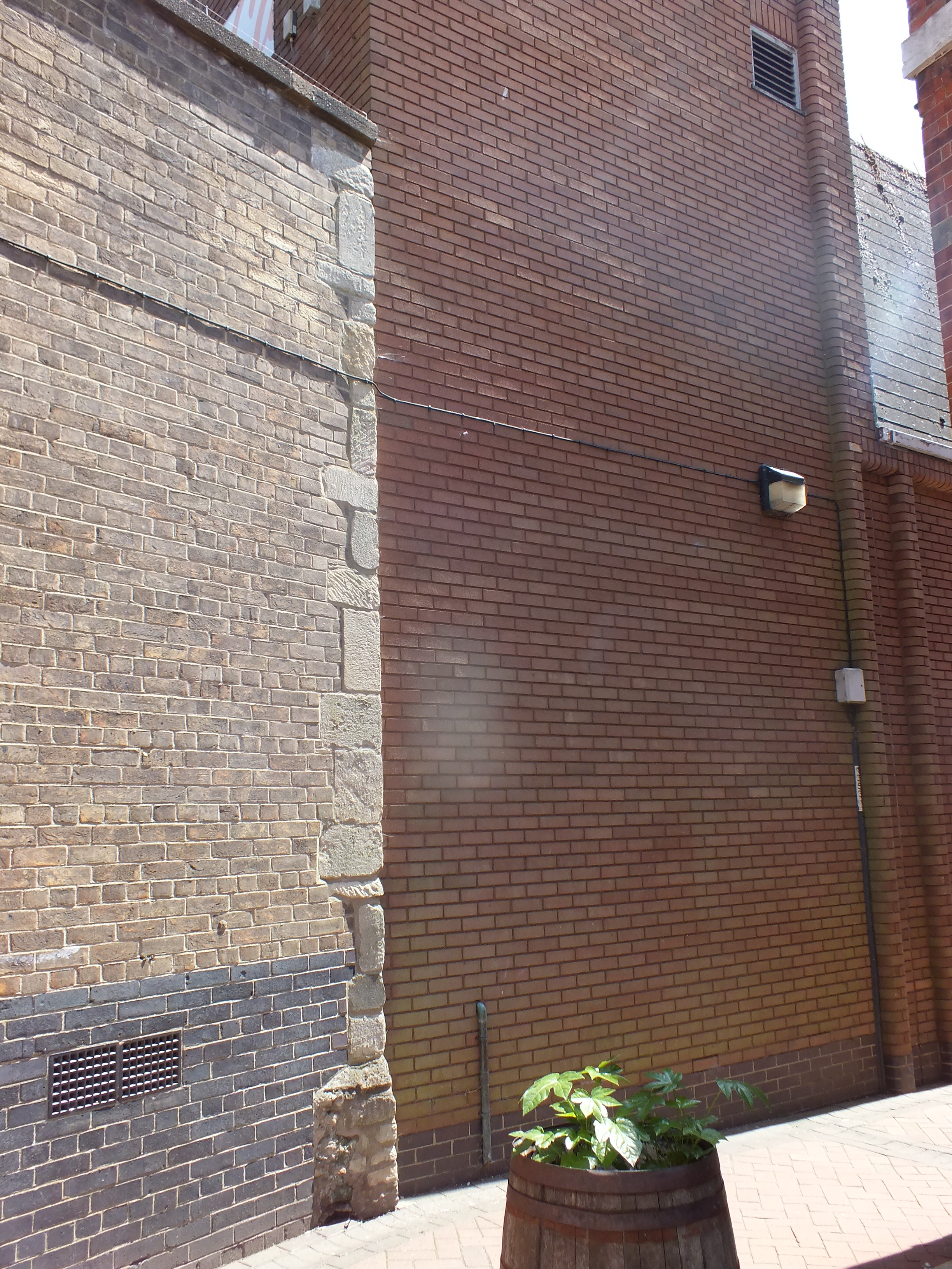
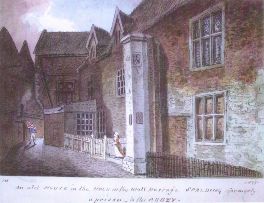
A very peculiar fragment down a curiously named alleyway off Market Place, built into the end of a yellow-brick wall with blue-brick plinth, now hemmed against a red-brick-faced plant room related to the construction of a department store in 2001-4. Until 1960 it was an ashlar-faced “tower”, demolished when Boots the Chemist expanded their store back along the Hole-in-the-Wall Passage connect to Francis Street. Hollar does not record the feature (although Hole-in-the-Wall Passage does correspond with the N-S boundary he has running up from Abbey Buildings that seems to form the eastern boundary of the inner precinct), nor does it appear directly on the Grundy Map of 1732.36
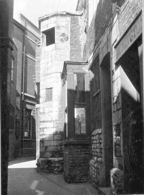
National Buildings Record AA52/9810, dated 1952, received 26 Jan 1953.
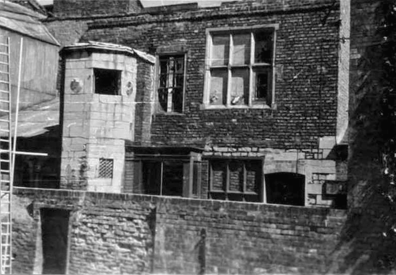
The feature was investigated by Inspectorate of Ancient Monuments c.1960 who deemed it to be only three hundred years old and “not worth preserving”(!).37 Even if it was remade from old masonry rather than an in-situ feature related to the monastic complex (which does rather beg the question of why anyone in the seventeenth century would build what looks like a stair turret on the front of their house), it is still a great shame it mostly ended up seemingly pulverised. It appears to have been a half-octagon of well-cut ashlar over coarser masonry which must be exposed footings, with what would seem to be a mouchette wheel carved into the ashlar on its south (and possibly west) side. The mouchette wheel could either be a decorative piece of stonework, or it could be a small aperture for lighting the interior of a stair turret, filled in. A brick buttress ran up its south side which formed its direct interface with the likely seventeenth-century brick house with stone mullion-and-transom windows that it was demolished alongside in 1960.
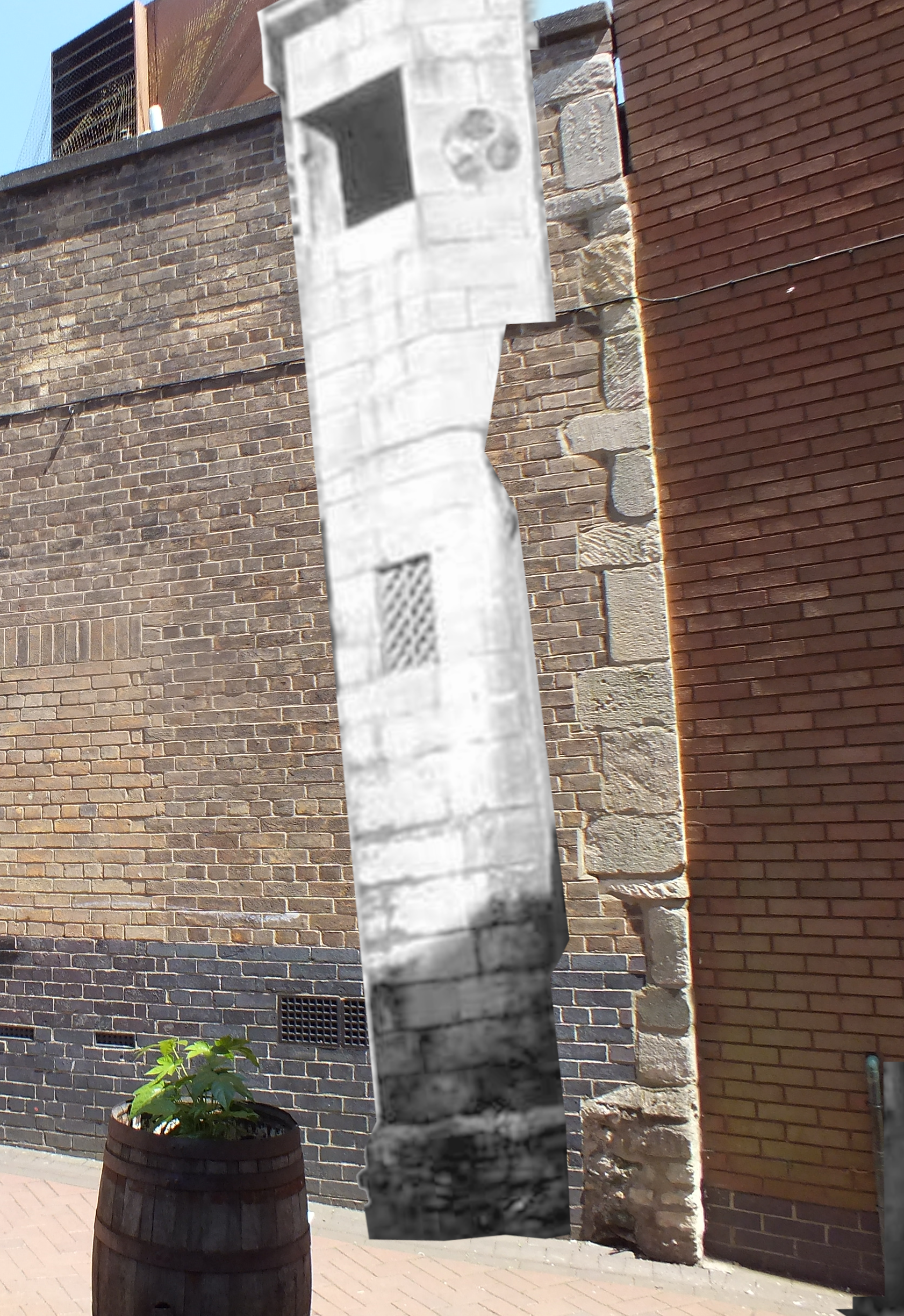
As the ashlar did not directly course with the outer wall of the original house, it is curious it was preserved at all as quoining in the 1960s wall. Comparing what survives to the photograph of 1952, the stones do seem to correspond with the ashlar coursing, which would advise the stone second-from-the-top is at least part of the “mouchette wheel” stone.
Have a look to the right and see what you think. Yes, the edge of the lower parts were obscured on the pre-demolition photography by the ground-floor bay window, but it’s interesting how they sort of line up.
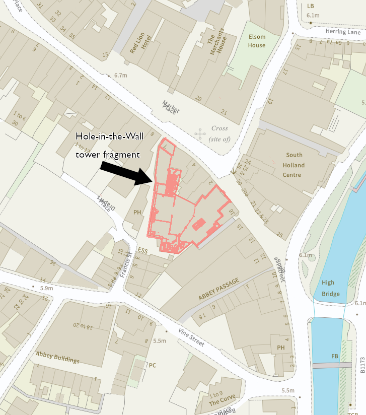
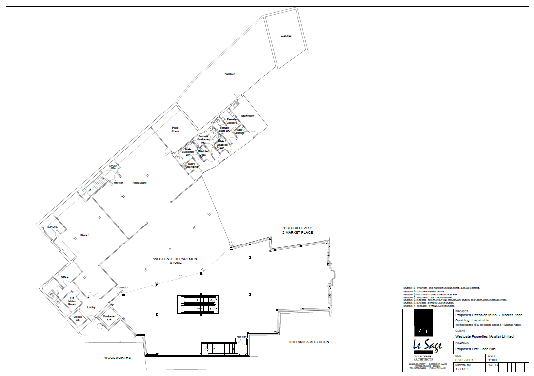
Both walls aside the “tower” fragment are now the same premises under one freehold, as the nineteenth-century front that was formerly Boots The Chemist was linked to a department store built 2004 with its main post-modern front on the site of 1 Market Place. Formerly occupied by long-running department store chain Beales (who went into administration in January 2020, and who after a brief corporate bail-out, finally shuttered its last few stores after 144 years in May 2025), the current lease is to East Midlands company The Furniture Warehouse. You can see the size of 7 Market Place and its original floor plan as designed in 2001 in the slideshow below, if you’re in to that sort of thing. I know I am!
The Great Gatehouse
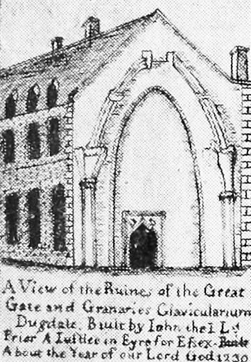
Although by no means do I intend to be exhaustive here, the remaining feature mentioned by Hollar is the oddly-titled “Clavicularium“, but clearly meaning the main gatehouse into the priory’s inner precinct from Sheep Market.38 This survived into the nineteenth century as the gable end of a building facing into Sheep Market before it was demolished at some point (unrecorded but surely before the 1830s) for The Crescent road which leads into the former precincts of the Priory and since the pedestrianisation of the market place is the main avenue of traffic through the town. It is clear it was the inner face of a gatehouse, with traceried springers and wall-ribs advising of a fan-vault over, a good example of the latter can be seen in the north porch of the parish church. The doorway in the brickwork was likely remounted from elsewhere as surely the whole arch would have been originally open as a vehicle arch (with a smaller pedestrian arch to the side).

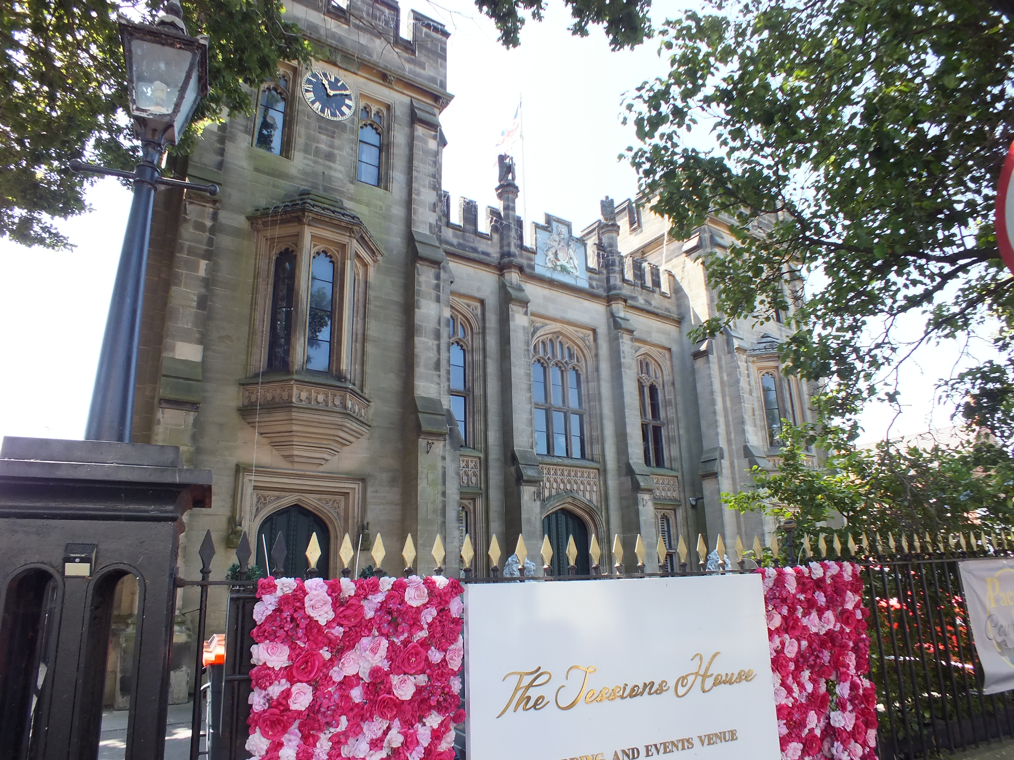
The commanding position of the great gate at the angle of Sheep Market has since been usurped by the former Sessions House of 1842, which is almost Disney-esque in its mock-Tudor ashlar crenelated cardboard-thin grandeur. Magistrates court hearings went on here until 2012 when a safety assessment found the detention spaces were below standard, and custodial cases were moved to Grantham and non-custodial cases to Boston.39 The current owners are pushing it all out as a wedding venue.40 Best of luck to them.
The parish church of St Mary and St Nicholas
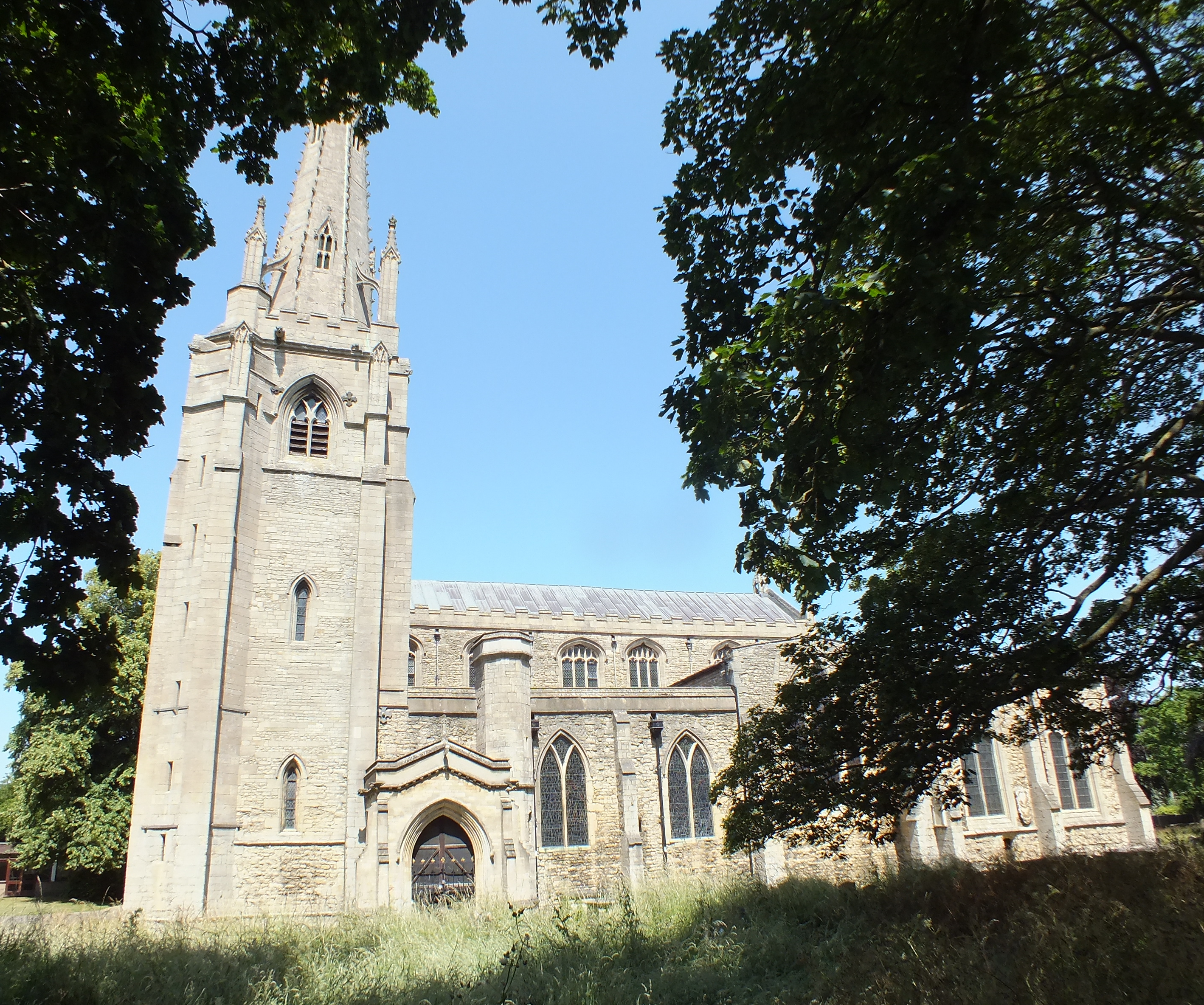
Beforehand my only real experience of Spalding was the medieval parish church on the opposite bank of the River Welland to the market place/modern town centre. It was moved here in 1284, and there is a remarkably detailed agreement between the priory and the parishioners which deserves to be better known.41 The document sets out that the current parochial church of Spalding within the monastic precinct is in a ruinous state, and the graveyard is too small, so the Bishop of Lincoln (Oliver Sutton) arranges that a new parish church should be built “on the other side of the water” in a cemetery which once had a chapel dedicated to St Thomas Becket. After the reuse of the materials of the old parish church, the cost was to be borne by the prior and convent, with the parishioners contributing a lump sum of £100 within a year of the completion of the work. The lengths of the arms of the church building are also specified, and closely correspond with the church that stands today.42 The transepts are specified to have a height and width similar to the church of the adjacent village of Moulton (crux […] cum altitudine et latitudine ad modum ecclesiae de Multon), which seems to have meant the clerestory windows with steeply-pitched sills.43 That a pair of parish church transepts would have aisles on either side like a nave was exceptional and must have appeared particularly prestigious alongside Spalding’s neighbouring settlements such as Moulton.
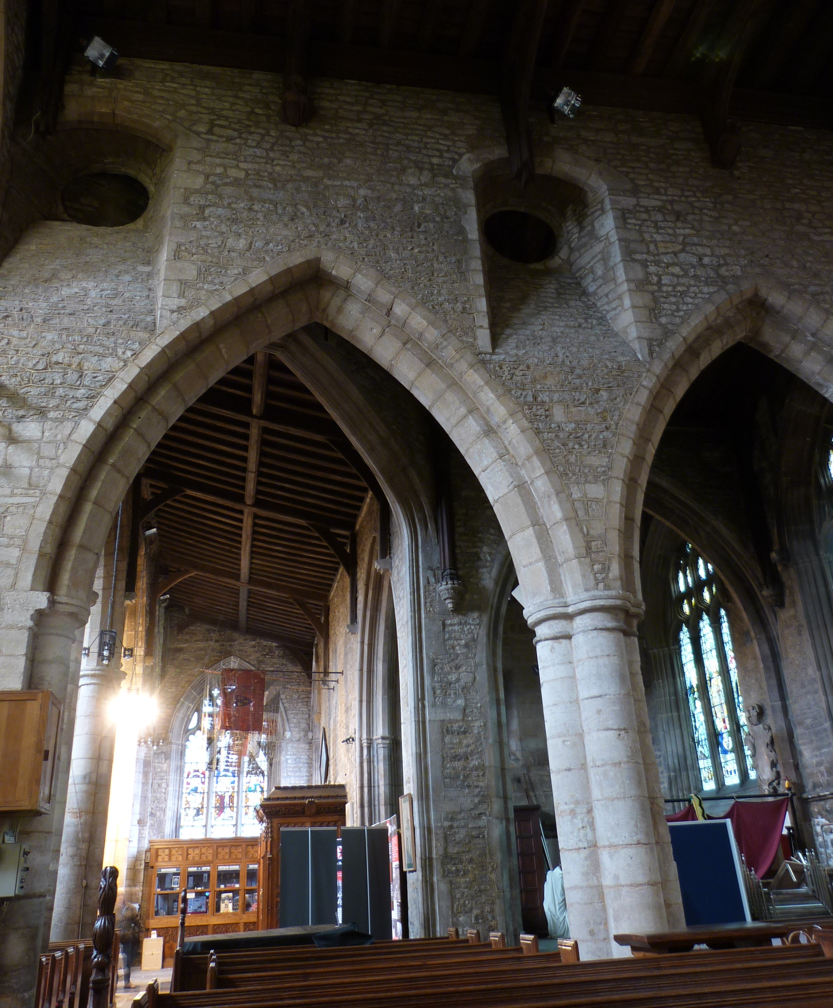
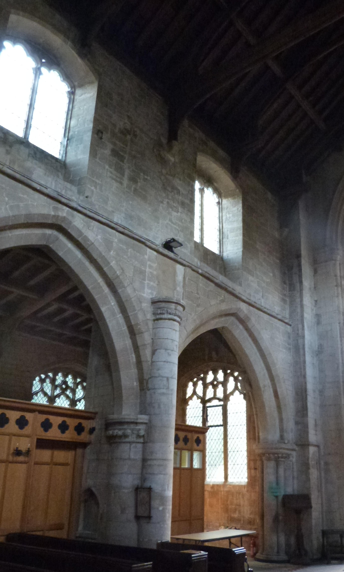
The agreement specifies that the priory’s initial build does not include a bell tower (absque campanario), although they are to give the parish two bells to the value of £20. Twenty pounds was a lot of money, but then bells were expensive things.44 One cost the parish of Bridgwater (Somerset), a similar inland port to Spalding that exploded in importance due to the wool export industry in the fourteenth century, over £13, 13 s., 6 d..45 As the lower stages of Spalding’s tower are similarly thirteenth-century in style, it must have been begun by the parish fairly soon after the move, perhaps even built immediately as a free-standing structure as was relatively common in Fenland parishes, and later interfaced to the aisle walls.46
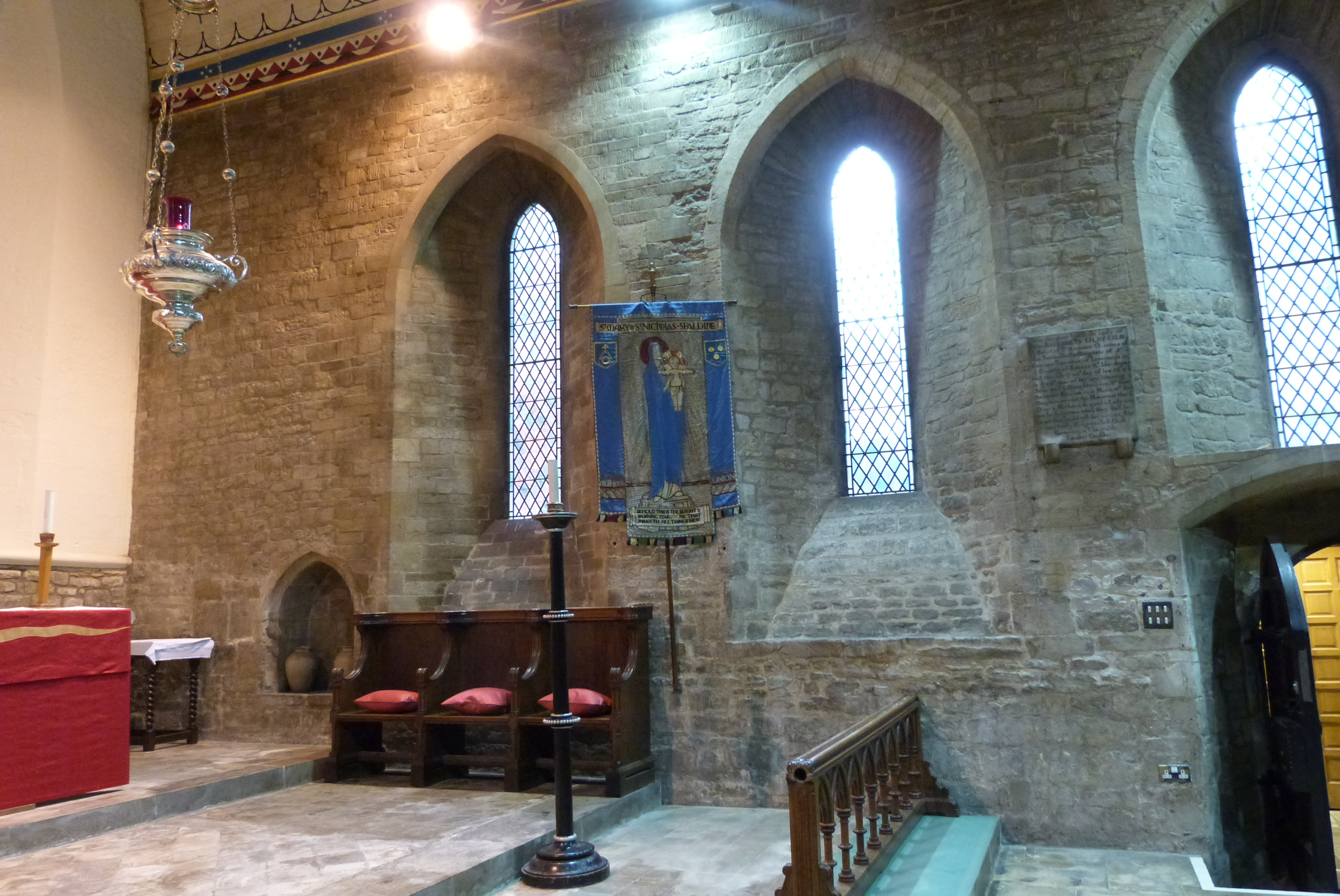
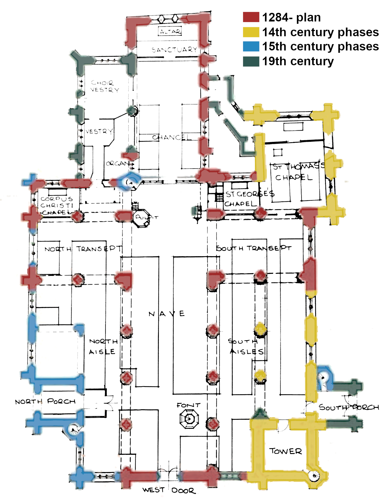
Getting monks to provide funds for a new parish church build out of their own income – which goes against why they have ownership of parish churches in the first place, in order to give them income – can be paralleled with the more commonly-cited charter of c.1180 where the monks of Castle Acre Priory are only granted the advowson (and thus permitting them to appoint themself as beneficiary of the income of its tithes) of Long Sutton parish on condition of them organising and funding the construction of a church on a new site.47 Like Long Sutton’s extremely long, well-built, but strikingly stylistically retardataire for c.1180 nave, Spalding’s cruciform church with eastern and western aisles almost seems like an over-provision by the monks, but at the the same time, stylistically the deep lancets of the chancel (above) are extremely old-fashioned for 1284. The building was quickly modernised and developed, its cruciform shape was filled in with an outer south aisle joining to a tower with belfry and eventually spire over, and then a chapel and porch almost squaring off the north side, as a phased plan shows.
Left: phasing of St Mary and Nicholas, Spalding, showing the cruciform church with transepts with eastern and western aisles built by the Priory in red.48
The precise phasing and dating of the 14th and 15th century work deserves further attention beyond the broad categorisation given on the plan: not least the St Thomas chapel off the S transept E aisle. It is local tradition that this chapel was founded in 1315 by Richard Skinner, a merchant of the Staple and member of the Spalding guild of Mercers.49 This may well be (I am unable to corroborate it via looking in the Crown Patent Rolls and similar), but the actual building is clearly Perpendicular, but it is of a wayward enough design to be late or even mid 14th century. Since the Priory was relatively well-connected with the Crown, it is possible the burghers of Spalding managed to get the most avant-garde court-connected masons to work on their parochial building.
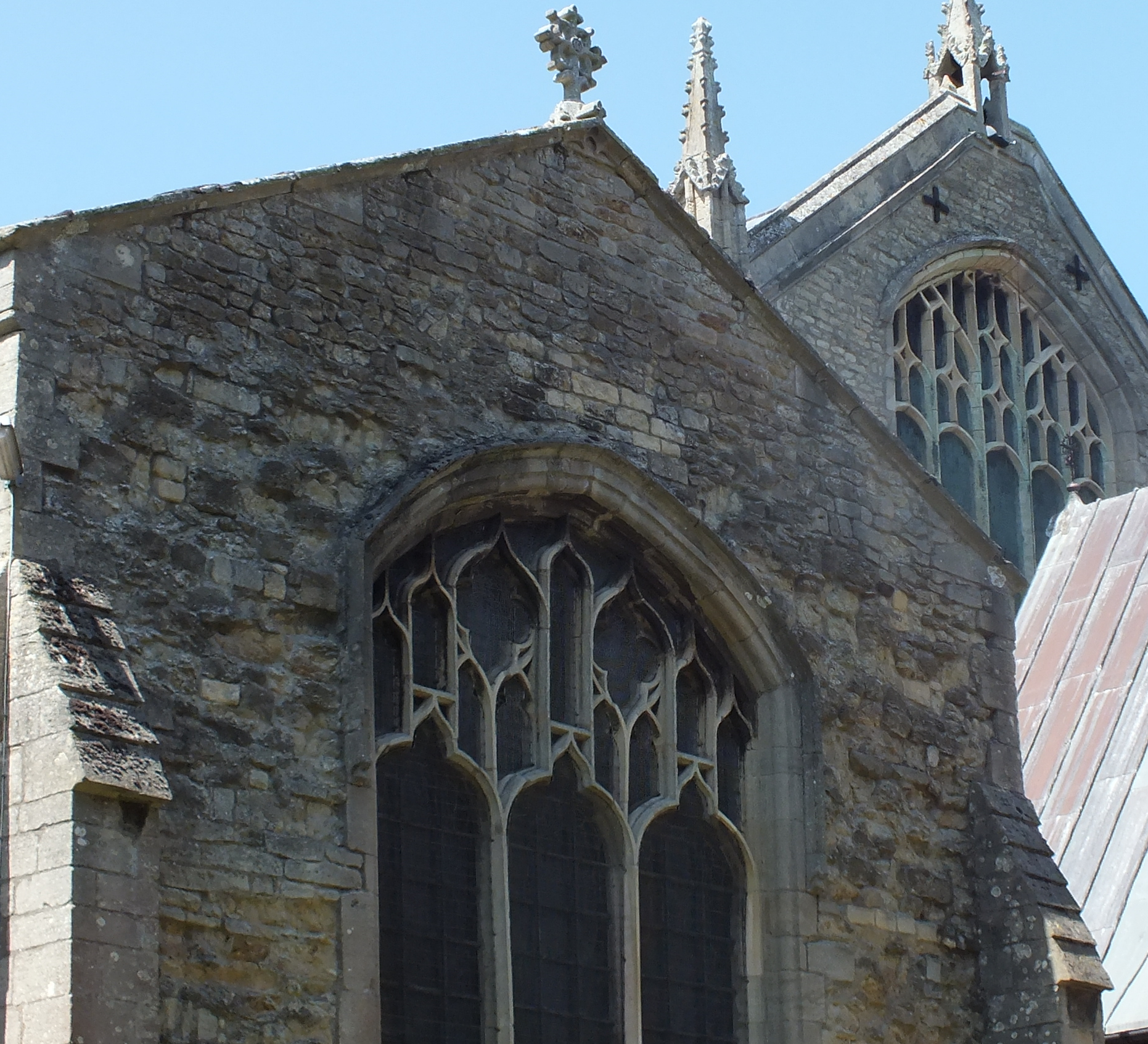
Upper right, the east window in the gable of the added clerestory that sits above the chancel roof is an element more commonly found in the Cotswolds.
Ayscoughfee Hall
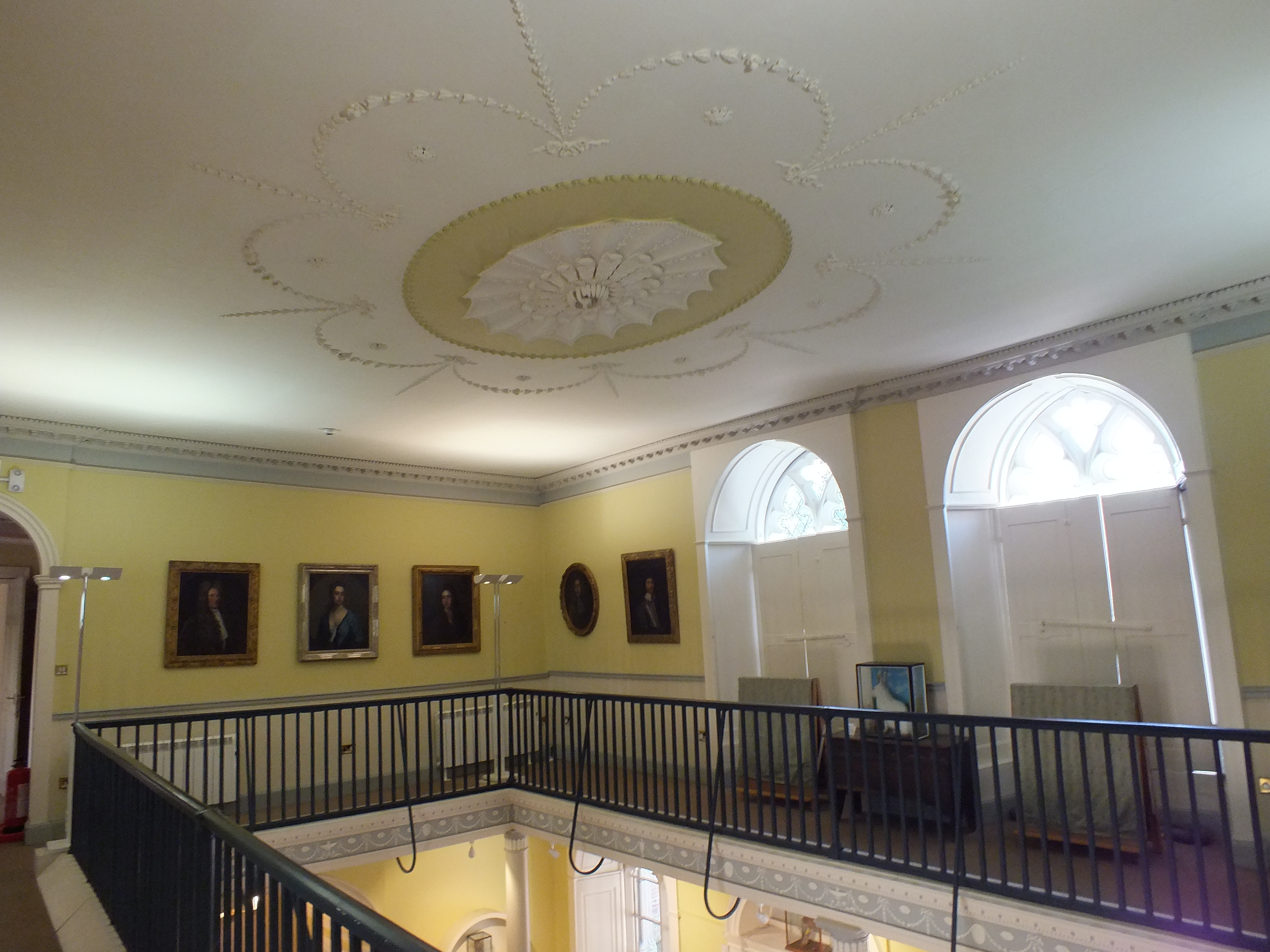
A bonus. As the parish church was all locked up this time, I ended up instead with a quick visit to the spectacular District-Council owned Ayscoughfee Hall alongside it, an exceptional survival of a fancy merchant’s house outside of a major medieval city.
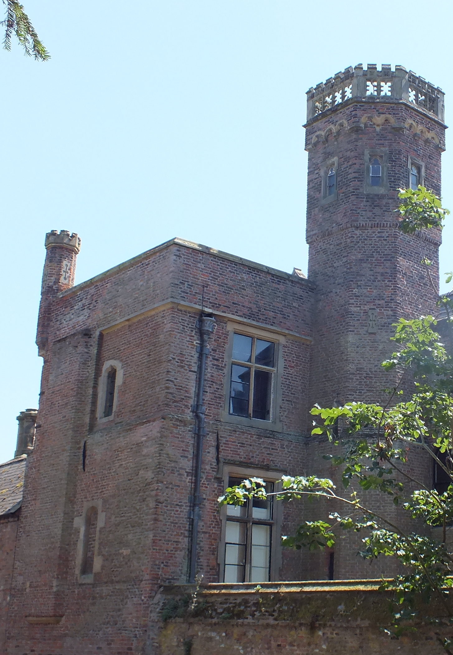
The stair turret was raised in the 19thc with a fenestrated top stage with a corbelled-out parapet with faux-machicolations with pierced crenelations.
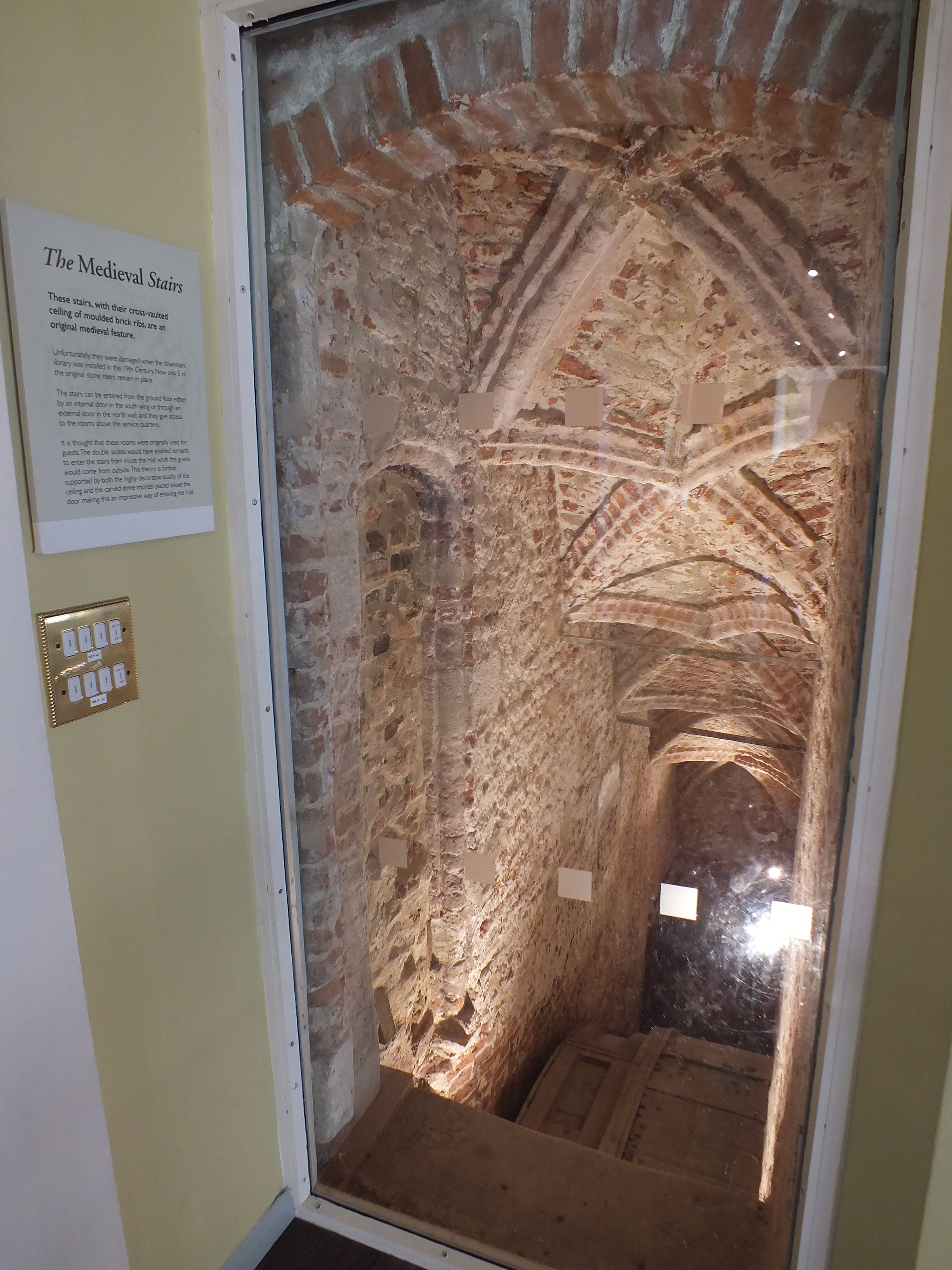
Coming up from the old parish church back towards the river and the town centre, the northern tower block catches your eye as something clearly Very Old. Then, to your delight, you find that this building is not only open to the public but also free entry, so you can whip round it in less than ten minutes (even though it deserves many more). In a standard “H”-plan, the north block linked to a great hall, since entirely clad in the Regency Adamesque style with a gallery, interfacing with a parallel service block with a striking brick-vaulted stair to the upper chamber to form the other side of the “H”. Certainly a place to return to, particularly if you get above the ceilings, since it retains essentially all of its original medieval roof carpentry.50 Visiting here gives you the added dimension of medieval Spalding aside from the priory, of the wealth of its private citizens in what was must’ve been like a “millionaires’ suburb” around the parish church.51
So that’s some of the very interesting place that is Spalding! I will be keeping an eye on developments in the town, especially the Old Johnson Hospital, and hope to return very soon. It’s a town with a lot of potential going forward. And if only one day someone could do some investigative archaeology on the site of the council offices, perhaps we could find something of that great priory church….
Footnotes
- An extremely useful source was Richard Buck “The Demise of Spalding Priory“, part of a BA dissertation, 2009. Buck was curator of archaeology at Spalding Gentleman’s Society and sadly died in 2024 aged 55/6. ↩︎
- https://discovery.nationalarchives.gov.uk/details/r/C3982540. ↩︎
- The Pinchbeck Fen map awaits proper publication (it clearly is an extraordinary object in so many ways, it deserves an edited multi-contributor volume on every aspect from its position in the map-making tradition, Fenland hydrology, perceptions of parish church architecture, medieval land laws etc.). Until then, the publications are: Rose Mitchell and David Crook “The Pinchbeck Fen Map: A Fifteenth-Century Map of the Lincolnshire Fenland” Imago Mundi 51 (1999), pp. 40-50 https://doi.org/10.1080/03085699908592902. David Crook “Churches and Chapels on a Fifteenth-Century Monastic Map of the Lincolnshire Fenland” in The Church and Learning In Later Medieval Society: Essays in Honour of Barry Dobson, Proceedings of the 1999 Harlaxton Symposium, Harlaxton Medieval Studies, XI eds Caroline M. Barron and Jenny Stratford (Shaun Tyas, 2002), pp.41-50. The highest resolution photograph I have obtained is published alongside Rose Mitchell’s entry “Of God, Man and Sheep: A Medieval Landscape” in Peter Barber ed. The Map Book (Weidenfeld & Nicholson, 2005), pp.68-9, which is unfortunately incomplete and still not detailed enough to decipher all of the legends. And I have tried.
↩︎ - Although the Grundy Map itself does not mention the source of the depiction of the lost priory church, in a later eighteenth-century account of Grundy’s map it is explained as “A view of the old coventual church from a drawing on a velum map made before the Dissolution, penes M. Johnson” “Account of the Gentleman’s Society at Spalding”, Antiquities in Lincolnshire, being the Third Volume of the Bibliotheca Topgraphica Britannica (J. Nichols, 1790), p. 70. Maurice Johnson was the founder of Spalding Gentleman’s Society. ↩︎
- “In omnibus his curiam prioratus ampliavit, domos aedificavit, ecclesiam veterem in novam construxit, et claustrum novum, dormitorium, infirmariam, cameram suam, domos hospitum; et magna vasa senea in bracina de novo emit.” J. A. Giles Chronicon Angliae Petriburgense (D. Nutt, 1845), p.141.
↩︎ - “Houses of Benedictine Monks: The priory of Spalding” in A History of the County of Lincoln: Volume 2, ed. William Page (HMSO, 1906), pp. 118-24. Volume 2 is the only VCH Lincolnshire that was ever produced, and while it is extremely useful to have, like much of the first wave of the VCH it has dated considerably. ↩︎
- English: Henry T. Riley (trans.) Ingulph’s Chronicle of the Abbey of Croyland (Henry G. Bohn, 1854), p. 131
Latin: Rerum Anglicarum Scriptorum Veterum, Tom. 1 (Oxford, 1684), p.65 ↩︎ - English: Riley (trans.) 1854, pp. 143-5
Latin: Rerum 1684, pp. 71-2. ↩︎ - Neal Sumner “The Countess Lucy’s Priory? The Early History of Spalding Priory and its Estates” Reading Medieval Studies 13 (1987), p.82. ↩︎
- Sumner, pp. 83-5. ↩︎
- Sumner, pp. 86-7. ↩︎
- “Ipse autem ad suum convivium in civitate Londoniensi regem invitavit, cum comitibus et baronibus; et, ut hoc obtineret, munera larga diversis magnatibus dedit: quapropter episcopus Lincolnie multum sibi erat infestus, et eum deposuisse voluit a sede sua.” Chronicon Angliae Petriburgense, p.141. ↩︎
- John Caley and Henry Ellis (ed.) Monasticon Anglicanum: A New Edition, Vol. 3 (James Bohn, 1846), p. 210. Sadly it is not cited. While it is probably true, I will need to research Edward II’s itinerary beyond what is available on the Internet to confirm. ↩︎
- I do not know where Hollar got “Irinius”, which presumably relates to the iris plant. This reading comes from the 1718 edition of the Monasticon, p. 40 ↩︎
- The inscriptions are often overlooked on Monasticon prints. Here the dedication at top reads:
“Quod Thoroldus olim cum nihil fecit ex lapide
Id ipsum hodie ne in nihilum recidit resecit ex aere
(qui ab eodem Thoroldo genus)
cum nomine ducit
Guil. Thorold Eq. aur.“
that is:
“That Thoroldus once with nothing, made out of stone
That thing this day, lest it fall into nothingness, is cut out of brass [i.e., the print plate]
(he who is from the same Thorold descended)
with the name
William Thorold, gilded knight [Knight Bachelor]”
↩︎ - This is entirely speculation on my part, but from summaries of the building works of the priors and their status in royal court show their residence must have been significant and this seems an ideal location for it. Because of the association of the Hole-in-the-Wall tower with the church of the Holy Rood, this area has been traditionally held to be the location of the lay burial ground mentioned as too small in 1284. In c. 1837 “upwards of forty stone coffins” were found excavating the cellars of new buildings on Bridge Street, which is to the north-east of the precinct. William White Gazeteer and Directory of Lincolnshire and the City and Diocese of Lincoln (William White/Simpkin, 1872) pp. 755-5. ↩︎
- The small square enclosure east of the “Situs Abbatæ” towards the River Welland is elementary to speculate as the site of a priory watermill, but remains speculation as I have not come across any mention that Spalding Priory had a mill. Since the same thought would likely have occurred to Hollar while he was making the plate, yet he refrained from labelling it as such discourages the theory. ↩︎
- Charles Warren Spalding The Spalding memorial: a genealogical history of Edward Spalding of Virginia and Massachusetts bay and his descendants (American Publishers Association 1897), pp.35-6. The original is held by Spalding Gentleman’s Society. ↩︎
- St Peter’s was evidentially a poorer sibling of the G.G. Scott-designed St Paul, Fulney begun 1877 (a year before his death) which even among the copious medieval steeples around Pinchbeck Fen cannot fail to catch your gaze on the main north approach to Spalding immediately off the roundabout on the A16. It is also of red brick but with copious Ancaster stone dressings and E.E. details, and a commanding masonry spire. Scott probably did at least visit both sites for the new-build churches as he led the restoration of the medieval parish church from 1865 onwards. Pevsner wasn’t particularly rude about St Peter, but gave it no praise with the following assessment: “Now deconsecrated and at the time of writing for sale. Of brick, large, with lancet windows, circular clerestory windows, and no tower. In the W front the W portal carries on its arch the mid-buttress which carries the bell-turret.”, Nikolaus Pevsner and John Harris The Buildings of England. Lincolnshire, Pevsner Architectural Guides (Penguin, 1964), p. 650. ↩︎
- Kelly’s Directory 1930 noted “services are at present suspended”, quoted at https://slha.org.uk/catalogue_item/spalding-st-peter ↩︎
- The 1991 building interfaces via a plate-glass steel-framed corridor with an earlier single range with a hipped roof that was built as Spalding Rural District Council offices before the demolition of Scott’s St Peter, in fairly strict Neo-Georgian style with sash windows that you would think was 1930s, but is in fact from 1954, Nikolaus Pevsner and John Harris, rev. Nicholas Antram The Buildings of England. Lincolnshire, Pevsner Architectural Guides (Penguin, 1989), p. 678. The 1964 edition does not mention it. ↩︎
- The only other work I can find by them after the briefest of searches is the former Hatchett’s Hotel on Piccadilly at the junction with Dover Street, of 1884. Simon Bradley and Nikolaus Pevsner The Buildings of England. London 6: Westminster, Pevsner Architectural Guides (New Haven UP, 2003), p. 562. ↩︎
- “Looking back at a former ‘jewel in Spalding’s crown’”, Lincs Online, 22 Oct 2020. Link|Archive ↩︎
- The £180,000 sum is from the Land Registry. “Did sale of Spalding’s Old Johnson Hospital give district value for money?” LincsOnline 3 May 2022, Link|Archive ↩︎
- “Owners of Spalding’s former Johnson Hospital should have paid business rates says South Holland District Council leader”, Lincs Online 9 Dec 2024, Link|Archive; “Calls made for a change in the law on business rates to tackle issues with rogue Spalding property owners” Lincs Online 8 Jan 2026, Link|Archive ↩︎
- “Dyden Ltd, a company based in the British Virgin Islands whose listed shareholders are “business management consultants” SMP Helm Trust Limited who are based in Jersey.” “Listed status bid for hospital fails” The Spalding & South Holland Voice, 6 Nov 2019 Link |Archive ↩︎
- “Appeal to report issues with former Johnson Hospital in Spalding to help authorities take action against owners” Lincs Online, 10 March 2026 Link|Archive. This YouTube interview then leader of South Holland District Council is interesting on the details of the problems with the property, not least that it is filled with asbestos that would prevent it being the focus of a community project without serious money being spent on it first, “Spalding Eyesores interview with South Holland District Council Gary Porter” VanLife Travels YouTube channel, 25 Feb 2022. Porter also suggests an ideal future that the Memorial Hospital becomes the South Holland District Council offices and the site of the 1991 building is sold for redevelopment. I would also hope, a proper bit of archaeology could take place. ↩︎
- It could also be a former internal dividing wall: if we take the Hollar map at face value, his depiction of the range on the north boundary of the conventual precinct is at least 11 bays long, rather than the 7 that exists today. How it may have been cut down is a question I wish I had pondered more while I was there, although as they are private homes you don’t want to push your luck having a nosy. ↩︎
- Abbey Buildings does not even seem to front on to the partly-lay-accessible inner precinct, but according the Hollar plan straddles the boundary between the conventual precinct and the mysterious north-east quarter. ↩︎
- Although an aisled hall with chapel would be more typical for the infirmary of large Benedictine house with late eleventh-century origins, this comparison is drawn with surviving block of the Franciscan Friary at Lincoln, following the assessment of David Stocker “The Remains of the Franciscan Friary in Lincoln: A Reassessment” in Archaeological papers from York presented to M.W. Barley (York Archaeological Trust, 1984), pp. 137-144. The Lincoln range has a masonry-vaulted undercroft, and also its interpretation has been revised in the current restoration, which as of 2025 is drawing to a close for a potential opening to the public in 2026.
A surviving domestic monastic range that originally had a timber floor as an undercroft is the lay brothers’ accommodation at Whalley Abbey (Lancashire), but this is the west range of the cloister where Cistercians tended to put their laybrothers. ↩︎ - Rightmove at time of publication. No. 7 is the strange one going for over quarter of a million. It clearly cannot be worth that even it does have the added fenestration of the west gable end. Absolutely burying this in the footnotes as I only want to be positive about the place in the main text, but if you’ve been to Spalding recently, you’d understand why you wouldn’t spend so much for a pokey terrace right in the centre of it. ↩︎
- Official HE list entry. ↩︎
- “Spalding micropub the Prior’s Oven celebrates 10 years in business” LincsOnline 19 Dec 2023 Link|Archive ↩︎
- The ales appear to be The Bounder, 3.8 ABV (Leatherbritches Brewery, Ashby-de-la-Zouch), Hicks Cornish Ale, 5.0 ABV (St Austell Brewery, Cornwall), Rat in Black, 4.5 ABV (The Rat Brewery, Huddersfield). Onward, casketeers! ↩︎
- Buck 2009, p.28; Kelly’s Directory of Lincolnshire (Kelly & Co., 1885), p. 640. ↩︎
- Grundy however does show a fanciful depiction of the pre-1284 parochial church of the Holy Cross, and this may be related to the tradition that the Hole-in-the-Wall tower was its stair-turret, as mentioned in a 1902 booklet Spalding and Its Churches quoted in Buck 2009 p. 28. ↩︎
- Just to clarify the obvious here, that means they thought it was built in 1660. Buck 2009 p. 30 ↩︎
- Hollar (or Baronet Thorold) is getting it from the term “Clavicula” which is a defensive earthwork shaped like a collarbone. ↩︎
- “Response to the proposal on the future of Spalding Magistrates’ Court” Ministry of Justice, 25 Nov 2014. ↩︎
- “New owners of Grade II listed Sessions House in Spalding have big plans to do former court justice as wedding and events venue” LincsOnline 10 Jul 2024 Link|Archive; Website at: www.thesessionshouse.com | Archive ↩︎
- Marion Brassington St Mary and St Nicholas Spalding. 700 Years in the Life of a Parish Church (St Mary and Nicholas PCC, 1984, rev. 1991), p.9.
Printed in Latin in the John Caley, Henry Ellis and Bulkeley Bandinel Monasticon Anglicanum: Anew Edition, Vol. 3 (1846), pp. 228-9.
The text in translation was published in full in “The Thirty-Ninth Report of the Lincoln Diocesan Architectural Society” Associated Architectural Societies Reports and Papers, Vol. 16, Pt. 2, pp. lxxxix-xci. ↩︎ - The specified lengths are total length: 160 feet; length up to chancel, 100 feet; transepts, 30 feet. ↩︎
- Moulton may also have been used as a reference because its rectory was appropriated by Spalding Priory and therefore familiar to them. It has been forwarded that Moulton was rebuilt as a expression of the priory’s “lordship” of the church, particularly with reference to their great rivals at Crowland, although in my opinion the argument for purely voluntary monastic munificence leans a little towards the circumstantial. Duncan Givans, “Investment in Local Church Fabric in the Lincolnshire Fenlands c. 1150–c. 1210: Moulton and Whaplode” in King’s Lynn and the Fens: Medieval Art, Architecture and Archaeology, British Archaeological Association Conference Transactions, ed. John McNeill (Maney, 2008), pp.215-229. ↩︎
- “New bells could cost as much as a new chapel”, Gabriel Byng Church Building and Society in the Later Middle Ages (Cambridge UP, 2017), p.151. Of course, there is no reason that the bells here need be new, but it is the sheer amount of metal that makes them expensive. ↩︎
- The Bridgwater bell, which does not survive, is known from a preserved, apparently primary medieval document now in the South West Heritage Trust, Taunton (Devon), D/B/bw/3a. The text is widely published in translation, Henry Beauchamp Walters, Church Bells of England (Oxford UP, 1912) pp. 23-4, see also Henry Thomas Riley “Double Christian Name: Bell-Making, Temp. Edward I” in Notes and Queries, 5th Ser. Vol. 3, 23 Jan 1875 p.77. The date is a problem because the year is only given in the document as 12 King Edward, so it could be 1283/4, 1318/9 or 1338/9 depending on which Edward: the 1st fits better with the fact they did not feel the need to use a regnal number, the 2nd or 3rd fits better with the date of the existing tower of the parish church of Bridgwater. The final sum total of expenditure is not even anywhere near the true cost of the bell because 59% of the metal was provided in kind (that is, from kettles and platters etc. donated by the parish and melted down). Only £3, 11s., 11d. went into labour: the main cost was the material. The bell weighed in total 3,037 lb, which is a big bell, 1.4 tons, or in the usual measurement of bell weights, 27 cwt [hundredweight]. An 1868 bell of 25 cwt hangs in church’s tower today, which ranks 449th in weight on the online database of Dove’s Guide for Church Bell Ringers. We can speculate in the case of Spalding that the priory were to supply two sizeable bells of around 10 cwt each. ↩︎
- Philip McAleer “Surviving Medieval Free-standing Bell Towers at Parish Churches in England and Wales” Journal of the British Archaeological Association 156 (2003), pp.87-8 https://doi.org/10.1179/jba.2003.156.1.79. ↩︎
- For instance Dorothy Owen Church and Society in Medieval Lincolnshire (The History of Lincolnshire Committee, 1971) p.5. The problem with the charter, which is around 1180 (certainly before 1185 when its issuer William FitzErnis is dead), is much later than would be expected for Long Sutton’s nave which is thoroughly standard mid-period Anglo-Norman Romanesque with no Early Gothic elements whatsoever. However, its similarity to a monastic infirmary might reflect its unusual monastic patronage, see John McNeill “The Parish Church in 1200” in Towards an Art History of the Parish Church ed. Meg Bernstein (Courtauld Books Online, 2021).
The charter is copied into the Castle Acre Priory Cartulary, British Library, Harley 2110 f. 70v, which of course, before the cyber-attack of 2023 I would have been able to get the original Latin from. ↩︎ - I gave up making my own phasing, as it was too complicated without a careful examination of the fabric, instead this is derived from a photograph of a framed plan hanging in the church (by Dave Hitchbourne 28 July 2010, uploaded to WikiCommons), which is too low-res to read so I superposed it over the plan from Brassington 1984 rev. 1991. The east wall is generally accepted to be from a late Romanesque lengthening of the cemetery chapel, that is, pre-1284. ↩︎
- Brassington 1984, rev. 1991, p. 11. In the passage of text under the 1732 Grundy map it is stated “Richd le Skinner Mercht. of ye Staple of Ladys Chapell now ye Free Grammar School abt. 1315, in which year 24 Octr. the Ld. Pr. received and entertained K. G. Ed. 2d & his Court in a Splendid Mannor at his Priory here”, and under Grundy’s image of the parish church stated again “And the Free Grammar School thereto adjoyning Built by Mr. Richd le Skynner Mercht of the Staple about 1315.” Spalding 1897, pp.35-6. Richard le Skinner was indeed a citizen of Spalding in the early 14th century, see for instance him, among many, accused by executors of Hugh de Cressey of carrying away the deceased’s goods: 20 May 1318: Calendar of Patent Rolls, Edward II Vol. 3 (HMSO, 1908), p. 180. Records from the reign of King Edward II show that there were at least ten denizen exporters of wool based in Spalding who could, at least in retrospect, be termed “merchants of the staple”, the forerunner being a Richard who sent 442 sacks for export, from an overall total for the town of 1,109 sacks. T.H. Lloyd The English Wool Trade in the Middle Ages (Cambridge UP, 1977), p. 131. I intend to do more research on this, so um, watch this footnote. ↩︎
- David L. Roberts “Ayscoughfee Hall: the building of a great merchant’s house” Lincolnshire History and Archaeology 10 (1975), pp. 37-40. Dendrochronology on the timbers suggests a felling date of 1451 for whole roof structure, National Heritage List for England. ↩︎
- Next to Asycoughfee was Holyrood House: a medieval timber-framed core faced with brick in the late 18th century, with additions reusing medieval stonework and timbers from elsewhere, demolished 1959 (see note in Historic England archive). The 1960-2 town hall stands on its site, assessed by Pevsner shortly after its completion as “modern thank heavens and not imitation Georgian”, Pevsner and Harris 1964, p. 652. Current assessments are less enthusiastic: “From beautiful Spalding building to drab office unit”, LincsOnline, 20 Aug 2021 Link|Archive. ↩︎


